Click on a date/time to view the file as it appeared at that time.
| Date/Time | Thumbnail | Dimensions | User | Comment |
|---|
| current | 22:33, 19 March 2021 | 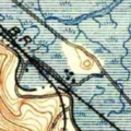 | 300 × 300 (184 KB) | JPxG | embiggen |
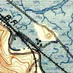
| 22:29, 19 March 2021 | 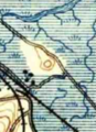 | 202 × 278 (115 KB) | JPxG | == {{int:filedesc}} == {{Information |Description=USGS aerial imagery of an island in the w:San Francisco Bay Area. Original map is from 1897, at 1:62500 scale. Image cropped from USGS historical map, available from TopoViewer. |Source=https://ngmdb.usgs.gov/topoview/viewer/ |Date=1897 |Author=USGS |Permission={{PD-USGov-USGS}} |other_versions= }} Category:Islands of California |
The following page uses this file:
This file contains additional information, probably added from the digital camera or scanner used to create or digitize it.
If the file has been modified from its original state, some details may not fully reflect the modified file.

