Click on a date/time to view the file as it appeared at that time.
| Date/Time | Thumbnail | Dimensions | User | Comment |
|---|
| current | 01:53, 21 November 2010 | 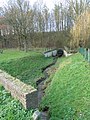 | 3,000 × 4,000 (3.64 MB) | Romaine | {{Information |Description={{en|1=Eyserbeek flows under the N281, Simpelveld, Limburg, the Netherlands}} {{nl|1=Eyserbeek gaat onder de N281 door, Simpelveld, Limburg, Nederland}} |Source={{own}} |Author=Romaine |Date=2010-11-20 |Permissi |
The following pages on the English Wikipedia use this file (pages on other projects are not listed):
The following other wikis use this file:
- Usage on es.wikipedia.org
- Usage on li.wikipedia.org
- Usage on nl.wikipedia.org
This file contains additional information, probably added from the digital camera or scanner used to create or digitize it.
If the file has been modified from its original state, some details may not fully reflect the modified file.
