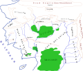
File:Sketch Map Of Beleriand.svg
Click on a date/time to view the file as it appeared at that time.
| Date/Time | Thumbnail | Dimensions | User | Comment | |
|---|---|---|---|---|---|
| current | 12:15, 18 July 2022 |  | 1,686 × 1,426 (224 KB) | Chiswick Chap | Lake detail |
| 12:40, 7 March 2021 |  | 1,686 × 1,426 (223 KB) | Chiswick Chap | adjust boundary | |
| 17:07, 24 February 2021 |  | 1,665 × 1,423 (223 KB) | Chiswick Chap | add labels, lakes | |
| 19:50, 10 February 2021 |  | 1,665 × 1,423 (196 KB) | Chiswick Chap | labels | |
| 14:47, 2 September 2020 |  | 1,665 × 1,423 (203 KB) | Chiswick Chap | fill mountains | |
| 18:38, 17 May 2020 |  | 1,665 × 1,423 (203 KB) | Chiswick Chap | far north | |
| 20:29, 14 May 2020 |  | 1,704 × 1,252 (190 KB) | Chiswick Chap | Uploaded own work with UploadWizard |
File usage
The following pages on the English Wikipedia use this file (pages on other projects are not listed):
Global file usage
The following other wikis use this file:
- Usage on bs.wikipedia.org
- Usage on cs.wikipedia.org
- Usage on fi.wikipedia.org
- Usage on fr.wikipedia.org
- Usage on pl.wikipedia.org
- Usage on ru.wikipedia.org
- Usage on sl.wikipedia.org
- Usage on uk.wikipedia.org