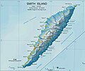
File:Smith-Island-Map-2010.jpg
Published by the Manfred Wörner Foundation, and hereby released by the Foundation’s President and CEO Apcbg (Lyubomir Ivanov) for publication under the Creative Commons Attribution ShareAlike 4.0 license.
Click on a date/time to view the file as it appeared at that time.
| Date/Time | Thumbnail | Dimensions | User | Comment | |
|---|---|---|---|---|---|
| current | 12:20, 21 August 2018 |  | 2,127 × 1,780 (822 KB) | Apcbg | Update |
| 11:23, 31 March 2017 |  | 2,127 × 1,780 (382 KB) | Apcbg | Update | |
| 19:28, 12 March 2017 |  | 2,127 × 1,780 (1.17 MB) | Apcbg | Update | |
| 15:50, 15 November 2016 |  | 1,465 × 1,227 (600 KB) | Apcbg | + scale | |
| 08:42, 15 November 2016 |  | 1,465 × 1,227 (596 KB) | Apcbg | Toponymy updated per SCAR Composite Gazetteer of Antarctica | |
| 17:25, 13 November 2016 |  | 1,465 × 1,227 (627 KB) | Apcbg | User created page with UploadWizard |
The following 80 pages use this file:
The following other wikis use this file:
View more global usage of this file.