Click on a date/time to view the file as it appeared at that time.
| Date/Time | Thumbnail | Dimensions | User | Comment |
|---|
| current | 14:06, 30 April 2016 |  | 3,859 × 2,383 (596 KB) | Hohum | Cartographic colours |
| 11:09, 3 April 2013 |  | 3,859 × 2,383 (597 KB) | Keysanger | Margin right and top cropped |
| 10:47, 3 April 2013 | 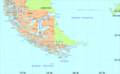 | 3,859 × 2,383 (597 KB) | Keysanger | "Estrecho Nelson" added Bigger Latitude and Longitude within the image empty margin cropped |
| 19:30, 3 May 2009 |  | 3,894 × 2,441 (639 KB) | Pitichinaccio | different colour |
| 19:29, 3 May 2009 |  | 3,894 × 2,441 (639 KB) | Pitichinaccio | {{Information |Description={{en|1=political map of southern Chile/Argentina: From Straits of Magellan to Cape Horn}} |Source=File:Sur2.gif |Author=User:Createaccount |Date=2008 |Permission={{GFDL-GMT}}} |other_versions=File:Sur2.gif }} <!-- |
The following other wikis use this file:
- Usage on af.wikipedia.org
- Usage on als.wikipedia.org
- Usage on ar.wikipedia.org
- Usage on ast.wikipedia.org
- Usage on br.wikipedia.org
- Usage on ca.wikipedia.org
- Usage on de.wikipedia.org
- Usage on de.wiktionary.org
- Usage on el.wikipedia.org
- Usage on eo.wikipedia.org
- Usage on es.wikipedia.org
View more global usage of this file.
This file contains additional information, probably added from the digital camera or scanner used to create or digitize it.
If the file has been modified from its original state, some details may not fully reflect the modified file.


