Click on a date/time to view the file as it appeared at that time.
| Date/Time | Thumbnail | Dimensions | User | Comment |
|---|
| current | 23:04, 18 February 2011 | 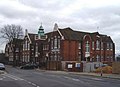 | 526 × 382 (115 KB) | GeographBot | == {{int:filedesc}} == {{Information |description={{en|1=Southend Adult Community College The college is housed in a former primary school in Ambleside Drive. Taken from the junction with Chase Road.}} |date=2008-02-22 |source=From [http://www.geograph.or |
The following pages on the English Wikipedia use this file (pages on other projects are not listed):
This file contains additional information, probably added from the digital camera or scanner used to create or digitize it.
If the file has been modified from its original state, some details may not fully reflect the modified file.
