File:Spilogale Putorius Range Map.png
Click on a date/time to view the file as it appeared at that time.
| Date/Time | Thumbnail | Dimensions | User | Comment | |
|---|---|---|---|---|---|
| current | 22:15, 1 July 2011 | 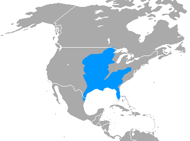 | 388 × 287 (9 KB) | Craig Pemberton | Update to use the same base map as the other Spilogales, first step in making a composite for the genus. |
| 19:09, 7 February 2010 |  | 449 × 374 (20 KB) | Nordelch | {{Information |Description={{en|1=Eastern Spotted Skunk (''Spilogale putorius'') range map, made by me with help of [http://www.aquarius.geomar.de/omc_intro.html www.aquarius.geomar.de], Map depending on the [http://www.iucnredlist.org/apps/redlist/de |
File usage
The following 4 pages use this file:
Global file usage
The following other wikis use this file:
- Usage on ar.wikipedia.org
- Usage on arz.wikipedia.org
- Usage on avk.wikipedia.org
- Usage on bg.wikipedia.org
- Usage on ca.wikipedia.org
- Usage on ceb.wikipedia.org
- Usage on cs.wikipedia.org
- Usage on es.wikipedia.org
- Usage on eu.wikipedia.org
- Usage on fa.wikipedia.org
- Usage on fi.wikipedia.org
- Usage on he.wikipedia.org
- Usage on ja.wikipedia.org
- Usage on ko.wikipedia.org
- Usage on lv.wikipedia.org
- Usage on nl.wikipedia.org
- Usage on nv.wikipedia.org
- Usage on pl.wikipedia.org
- Usage on pnb.wikipedia.org
- Usage on pt.wikipedia.org
- Usage on ru.wikipedia.org
- Usage on sv.wikipedia.org
- Usage on uk.wikipedia.org
- Usage on vi.wikipedia.org
- Usage on www.wikidata.org