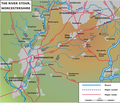
File:Stour Worcestershire.png
Click on a date/time to view the file as it appeared at that time.
| Date/Time | Thumbnail | Dimensions | User | Comment | |
|---|---|---|---|---|---|
| current | 11:15, 6 July 2009 |  | 3,400 × 2,905 (669 KB) | Sjwells53 | Frame restored |
| 11:04, 6 July 2009 |  | 3,400 × 2,905 (677 KB) | Sjwells53 | Improved coverage of tributaries | |
| 22:00, 2 July 2009 |  | 3,400 × 2,905 (652 KB) | Sjwells53 | Small labelling improvements | |
| 16:42, 2 July 2009 |  | 3,400 × 2,905 (653 KB) | Sjwells53 | Added tributaries. | |
| 15:28, 1 July 2009 |  | 3,400 × 2,905 (614 KB) | Sjwells53 | {{Information |Description={{en|1=Sketch map of the course of the River Stour, Worcestershire, Staffordshire and West Midlands, England, UK.}} |Source=Own work by uploader |Author=Sjwells53 |Date=July 2009 |Permission= |other_versions= |
File usage
The following page uses this file:
Global file usage
The following other wikis use this file:
- Usage on fr.wikipedia.org
- Usage on it.wikipedia.org
- Usage on sh.wikipedia.org