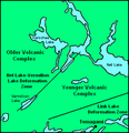
File:Strathy Township Geology.png
Click on a date/time to view the file as it appeared at that time.
| Date/Time | Thumbnail | Dimensions | User | Comment | |
|---|---|---|---|---|---|
| current | 04:44, 4 January 2011 |  | 322 × 334 (20 KB) | Black Tusk | include the Chambers-Strathy Batholith and naming for Arsenic Lake |
| 22:49, 3 January 2011 |  | 322 × 334 (17 KB) | Black Tusk | {{Information |Description={{en|1=Map of deformation zones and volcanic complexes in Strathy Township, Temagami, Ontario, Canada.}} |Source={{own}} |Author=Black Tusk |Date=2010-01-03 |Permission=See below |other_versions= }} [[Catego |
File usage
The following pages on the English Wikipedia use this file (pages on other projects are not listed):
Global file usage
The following other wikis use this file:
- Usage on it.wikipedia.org