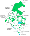
File:Sundbyberg Municipality Districts.svg
Click on a date/time to view the file as it appeared at that time.
| Date/Time | Thumbnail | Dimensions | User | Comment | |
|---|---|---|---|---|---|
| current | 08:54, 21 July 2020 |  | 720 × 856 (663 KB) | Narayanese | Remove streams (was missing one and had anorher wrong) |
| 10:24, 19 July 2020 |  | 720 × 856 (675 KB) | Narayanese | Näckrosen metro | |
| 09:46, 19 July 2020 |  | 720 × 856 (675 KB) | Narayanese | Added rail stations, Igelbäcken, Hallonbergen green areas | |
| 18:10, 18 July 2020 |  | 744 × 1,052 (650 KB) | Narayanese | {{subst:Upload marker added by en.wp UW}} {{Information |Description = {{en|Solid black line delineate districts in Sundbyberg municipality. Light gray lines show major roads. Dashed grey lines show rail. Blue shows lakes and streams. Green shows forests, parks and meadows.}} |Source = Freely drawn based on based on Sundybergskartan, from the municipality homepage. |Date = 2020-07-18 |Author = Narayanese }} |
File usage
The following pages on the English Wikipedia use this file (pages on other projects are not listed):
Global file usage
The following other wikis use this file:
- Usage on cs.wikipedia.org