File:Super Outbreak Map.jpg
From the National Weather Service, Courtesy of Ted Fujita (actual image link archive link)
Hoxit, Lee R.; Charles F. Chappell (October, 1975) NOAA Technical Report: Tornado Outbreak of April 3-4, 1974; Synoptic Analysis, Boulder: U.S. Department of Commerce, p. iv NOAA TR ERL 338-APCL 37
Author
Other versions
Hoxit, Lee R.; Charles F. Chappell (October, 1975) NOAA Technical Report: Tornado Outbreak of April 3-4, 1974; Synoptic Analysis, Boulder: U.S. Department of Commerce, p. iv NOAA TR ERL 338-APCL 37
-
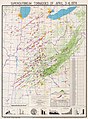 Source color map


|
This meteorology image could be re-created using vector graphics as an SVG file. This has several advantages; see Commons:Media for cleanup for more information. If an SVG form of this image is available, please upload it and afterwards replace this template with
{{vector version available|new image name}}.
It is recommended to name the SVG file “Super Outbreak Map.svg”—then the template Vector version available (or Vva) does not need the new image name parameter. |


This work is in the public domain in the United States because it was published in the United States between 1929 and 1977, inclusive, without a copyright notice. For further explanation, see Commons:Hirtle chart as well as a detailed definition of "publication" for public art.
|
 |

