File:The Low Countries.png
Click on a date/time to view the file as it appeared at that time.
| Date/Time | Thumbnail | Dimensions | User | Comment | |
|---|---|---|---|---|---|
| current | 19:07, 16 July 2022 | 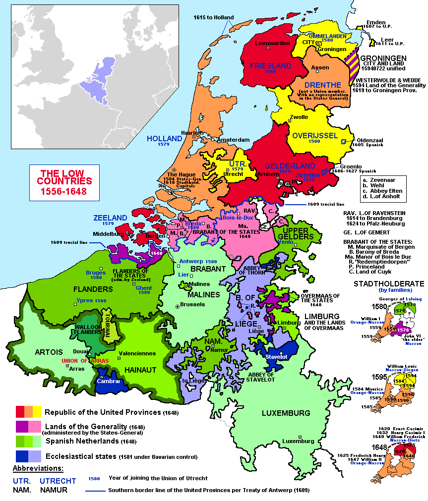 | 863 × 1,011 (88 KB) | Nederlandse Leeuw | Clearer distinction between Flanders and Walloon Flanders. Corrected 'Limburg of the States' to 'Overmaas of the States'. Full name Limburg-Overmaas. Year of colours is 1648. |
| 18:28, 16 July 2022 |  | 863 × 1,011 (88 KB) | Nederlandse Leeuw | Cambrésis blue, out of the Habsburg Netherlands and Union of Arras. Artois-Flemish border corrected. Tournai separate from Flanders. Union of Utrecht join date legend. | |
| 10:38, 14 September 2010 |  | 863 × 1,011 (46 KB) | Ed g2s | Borders | |
| 15:43, 14 March 2007 |  | 863 × 1,011 (46 KB) | DaisyDaisy | {{Information |Description=The Low Countries Map (1556-1648) |Source=en:Image:The Low Countries.png |Date=2006/12/08 |Author=en:User:Fresheneesz |Permission=GFDL |other_versions= }} |
File usage
The following 12 pages use this file:
- Bossong
- Historiography of the Eighty Years' War
- Ledringhem
- List of stadtholders in the Low Countries
- Low Countries
- Politics and government of the Dutch Republic
- Prince-Bishopric of Liège
- Redemptiedorpen
- Renaissance in the Low Countries
- Terminology of the Low Countries
- User:JMvanDijk/Sandbox4
- User talk:Qexigator/Books/Kingdom of Belgium, then and now
Global file usage
The following other wikis use this file:
- Usage on af.wikipedia.org
- Usage on ar.wikipedia.org
- Usage on ast.wikipedia.org
- Usage on be.wikipedia.org
- Usage on bg.wikipedia.org
- Usage on ca.wikipedia.org
- Usage on cs.wikipedia.org
- Usage on da.wikipedia.org
- Usage on el.wikipedia.org
- Usage on es.wikipedia.org
- Usage on et.wikipedia.org
- Usage on fi.wikipedia.org
- Usage on fr.wikipedia.org
- Usage on gl.wikipedia.org
- Usage on hu.wikipedia.org
- Usage on id.wikipedia.org
- Usage on it.wikipedia.org
- Usage on ja.wikipedia.org
- Usage on lt.wikipedia.org
- Usage on mk.wikipedia.org
- Usage on nl.wikipedia.org
- Usage on pl.wiktionary.org
- Usage on pt.wikipedia.org
- Usage on ro.wikipedia.org
- Usage on ru.wikipedia.org
- Usage on sh.wikipedia.org
- Usage on sl.wikipedia.org
- Usage on tr.wikipedia.org
View more global usage of this file.