Click on a date/time to view the file as it appeared at that time.
| Date/Time | Thumbnail | Dimensions | User | Comment |
|---|
| current | 02:25, 4 February 2011 | 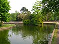 | 640 × 479 (180 KB) | GeographBot | == {{int:filedesc}} == {{Information |description={{en|1=The Pells The Pells is the name given to the wetlands on the north eastern side of the town. The bulk of the area between the river and the railway have been put aside as a reserve whilst the southe |
The following page uses this file:
This file contains additional information, probably added from the digital camera or scanner used to create or digitize it.
If the file has been modified from its original state, some details may not fully reflect the modified file.
