Click on a date/time to view the file as it appeared at that time.
| Date/Time | Thumbnail | Dimensions | User | Comment |
|---|
| current | 17:24, 24 May 2018 | 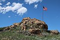 | 5,472 × 3,648 (8.41 MB) | Mr. Satterly | {{Information |description=The Rockpile in Gillette, Wyoming |source={{own}} |date=2018-05-23 |author=Mr. Satterly |permission={{WTFPL}} |other versions= }} Category:Gillette, Wyoming Category:Rock formations in Wyoming |
The following pages on the English Wikipedia use this file (pages on other projects are not listed):
This file contains additional information, probably added from the digital camera or scanner used to create or digitize it.
If the file has been modified from its original state, some details may not fully reflect the modified file.
