File:Three Sisters Topographic Map-en.gif
Original upload log
This image is a derivative work of the following images:
- File:Three Sisters topographic map-en.svg licensed with Cc-by-3.0,2.5,2.0,1.0, GFDL
- 2014-01-01T22:00:35Z Hike395 2835x3300 (4013017 Bytes) Ran scour.py to reduce size and improve standards compatibility
- 2013-04-27T18:00:49Z Hike395 2835x3300 (4947695 Bytes) {{Information |Description ={{en|1=Topographic map of Three Sisters Area, Oregon}} |Source =Translated from [[:File:Three_Sisters_topographic_map-fr.svg]] |Author ={{User|Bourrichon}}, translated by {{User|
Uploaded with derivativeFX
Add a one-line explanation of what this file represents
File history
Click on a date/time to view the file as it appeared at that time.
| Date/Time | Thumbnail | Dimensions | User | Comment |
|---|
| current | 00:04, 1 October 2023 | 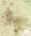 | 2,835 × 3,300 (1.2 MB) | Hike395 | better gif |
| 23:59, 30 September 2023 | 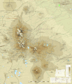 | 2,835 × 3,300 (935 KB) | Hike395 | == {{int:filedesc}} == {{Information |Description={{en|1=Topographic map of Three Sisters Area, Oregon}} |Source={{Derived from|Three Sisters topographic map-en.svg|display=50}} |Date=2023-09-30 23:55 (UTC) |Author=* File:Three Sisters topographic map-en.svg: {{User|Bourrichon}}, translated by {{User|Hike395}} * conversion to gif: [[User:{{subst:REVISIONUSER}}|{{subst:REVISIONUSER}}]] |Permission= |other_versions= }} == {{int:license-header}} ==... |
File usage
The following pages on the English Wikipedia use this file (pages on other projects are not listed):
Global file usage
The following other wikis use this file:
- Usage on es.wikipedia.org
- Usage on it.wikipedia.org
This file contains additional information, probably added from the digital camera or scanner used to create or digitize it.
If the file has been modified from its original state, some details may not fully reflect the modified file.


