Click on a date/time to view the file as it appeared at that time.
| Date/Time | Thumbnail | Dimensions | User | Comment |
|---|
| current | 22:00, 1 January 2014 |  | 2,835 × 3,300 (3.83 MB) | Hike395 | Ran scour.py to reduce size and improve standards compatibility |
| 18:00, 27 April 2013 | 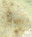 | 2,835 × 3,300 (4.72 MB) | Hike395 | {{Information |Description ={{en|1=Topographic map of Three Sisters Area, Oregon}} |Source =Translated from File:Three_Sisters_topographic_map-fr.svg |Author ={{User|Bourrichon}}, translated by {{User|Hike395}} |Date =... |
No pages on the English Wikipedia use this file (pages on other projects are not listed).
This file contains additional information, probably added from the digital camera or scanner used to create or digitize it.
If the file has been modified from its original state, some details may not fully reflect the modified file.


