Click on a date/time to view the file as it appeared at that time.
| Date/Time | Thumbnail | Dimensions | User | Comment |
|---|
| current | 20:10, 30 January 2010 | 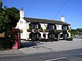 | 640 × 480 (120 KB) | GeographBot | == {{int:filedesc}} == {{Information |description={{en|1=Tong Village - The Greyhound Inn. A famous hostelry around these parts. Tong is a typical english village, church, pub and cricket ground which is to the right behind the blue car}} |date=2005-10-02 |
The following pages on the English Wikipedia use this file (pages on other projects are not listed):
This file contains additional information, probably added from the digital camera or scanner used to create or digitize it.
If the file has been modified from its original state, some details may not fully reflect the modified file.
