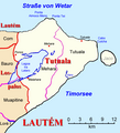
File:Tutuala Posto Administrativo.png
Click on a date/time to view the file as it appeared at that time.
| Date/Time | Thumbnail | Dimensions | User | Comment | |
|---|---|---|---|---|---|
| current | 13:43, 24 May 2010 |  | 984 × 988 (130 KB) | J. Patrick Fischer | correction of position of Vero and Pitileti |
| 09:35, 28 December 2009 |  | 984 × 988 (127 KB) | J. Patrick Fischer | New version by using File:Administrative map of the Lautem district of East Timor.png of Maximilian Dörrbecker (Chumwa) and new geographical names and spelling according Ministerial Document 199/2009, | |
| 20:40, 12 June 2009 |  | 1,285 × 1,415 (659 KB) | J. Patrick Fischer | new river name | |
| 20:12, 5 June 2009 |  | 1,285 × 1,415 (620 KB) | J. Patrick Fischer | {{Information |Description={{en|1=Map of subdistrict of Tutuala, district Lautém, Timor-Leste}} {{de|1=Karte des Subdistrikts Tutuala, Distrikt Lautém, Timor-Leste}} |Source=Eigenes Werk (own work) |Author=J. Patrick Fischer |
File usage
The following page uses this file:
Global file usage
The following other wikis use this file:
- Usage on de.wikipedia.org
- Usage on de.wikivoyage.org
- Usage on id.wikipedia.org
- Usage on vi.wikipedia.org