Click on a date/time to view the file as it appeared at that time.
| Date/Time | Thumbnail | Dimensions | User | Comment |
|---|
| current | 00:27, 3 April 2007 | 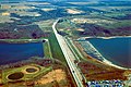 | 1,500 × 1,000 (393 KB) | DanMS | {{Information | Description = {{en|Barrier Dam on Saylorville Lake near Polk City, Iowa, USA. The main dam is Saylorville Dam, but in order to fill the lake, this second dam, Barrier Dam had to be constructed on one arm of the lake. }} | Source |
The following pages on the English Wikipedia use this file (pages on other projects are not listed):
The following other wikis use this file:
- Usage on en.wikivoyage.org
- Usage on es.wikipedia.org
- Usage on hu.wikipedia.org
- Usage on it.wikivoyage.org
- Usage on ru.wikipedia.org
- Usage on www.wikidata.org
This file contains additional information, probably added from the digital camera or scanner used to create or digitize it.
If the file has been modified from its original state, some details may not fully reflect the modified file.
