Click on a date/time to view the file as it appeared at that time.
| Date/Time | Thumbnail | Dimensions | User | Comment |
|---|
| current | 00:02, 6 April 2007 | 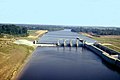 | 1,500 × 1,001 (319 KB) | DanMS | {{Information | Description = {{en|Columbia Lock and Dam on the Ouachita River in Arkansas, USA. The U.S. Army Corps of Engineers maintains the locks and dredges the river to maintain a navigation channel on the river.}} | Source = U.S. Army Co |
The following pages on the English Wikipedia use this file (pages on other projects are not listed):
The following other wikis use this file:
- Usage on bh.wikipedia.org
- Usage on cv.wikipedia.org
- Usage on es.wikipedia.org
- Usage on fa.wikipedia.org
- Usage on fr.wikipedia.org
- Usage on hu.wikipedia.org
- Usage on it.wikipedia.org
- Usage on la.wikipedia.org
- Usage on lt.wikipedia.org
- Usage on pl.wikipedia.org
- Usage on ru.wikipedia.org
- Usage on zh.wikipedia.org
This file contains additional information, probably added from the digital camera or scanner used to create or digitize it.
If the file has been modified from its original state, some details may not fully reflect the modified file.
