File:USA Mississippi Tupelo Area NPS Map.jpg
Click on a date/time to view the file as it appeared at that time.
| Date/Time | Thumbnail | Dimensions | User | Comment | |
|---|---|---|---|---|---|
| current | 21:41, 19 July 2007 | 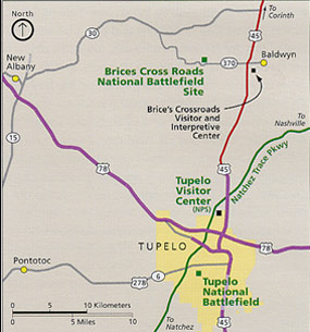 | 285 × 305 (28 KB) | Wikid77 | {{Information |Description=Area map of Tupelo, Mississippi, showing city limits, roads, and national parks or historic landmarks. Map by US NPS. |Source=US en:National Park Service webpage: http:// |
File usage
The following 4 pages use this file:
Global file usage
The following other wikis use this file:
- Usage on eo.wikipedia.org
- Usage on he.wikipedia.org
- Usage on ja.wikipedia.org
- Usage on ka.wikipedia.org
- Usage on nl.wikipedia.org
- Usage on pt.wikipedia.org
- Usage on sv.wikipedia.org