Click on a date/time to view the file as it appeared at that time.
| Date/Time | Thumbnail | Dimensions | User | Comment |
|---|
| current | 20:45, 8 July 2008 | 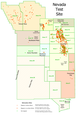 | 1,884 × 2,910 (339 KB) | Binksternet | {{Information |Description={{en|1=This is a derivative work. It is my retooling of a USGS map called "Geologic Surface Effects of Underground Nuclear Testing, Buckboard Mesa, Climax Stock, Dome Mountain, Frenchman Flat, Rainier/Aqueduct Mesa, and Shoshone |
The following pages on the English Wikipedia use this file (pages on other projects are not listed):
The following other wikis use this file:
- Usage on de.wikipedia.org
- Usage on eo.wikipedia.org
- Usage on he.wikipedia.org
- Usage on lb.wikipedia.org
- Usage on no.wikipedia.org
- Usage on ru.wikipedia.org
- Usage on uk.wikipedia.org
- Usage on vi.wikipedia.org
