File:USMC-M-Tarawa-3.jpg
Map of Betio, Tarawa Atoll;
Source
| Public domainPublic domainfalsefalse
|
Situation: 18:00, D+1
Landing strip on Betio islet, Tarawa atoll
Click on a date/time to view the file as it appeared at that time.
| Date/Time | Thumbnail | Dimensions | User | Comment |
|---|
| current | 07:23, 14 March 2005 | 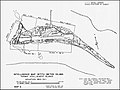 | 800 × 602 (77 KB) | Wwoods | Map of Betio, Tarawa Atoll; http://www.ibiblio.org/hyperwar/USMC/USMC-M-Tarawa/ {{PD-USGov-Military-USMC}} |
The following 5 pages use this file:
The following other wikis use this file:
- Usage on azb.wikipedia.org
- Usage on ca.wikipedia.org
- Usage on cs.wikipedia.org
- Usage on de.wikipedia.org
- Usage on es.wikipedia.org
- Usage on fi.wikipedia.org
- Usage on fr.wikipedia.org
- Usage on gl.wikipedia.org
- Usage on he.wikipedia.org
- Usage on id.wikipedia.org
- Usage on it.wikipedia.org
- Usage on ja.wikipedia.org
- Usage on nl.wikipedia.org
- Usage on pl.wikipedia.org
- Usage on pt.wikipedia.org
- Usage on ru.wikipedia.org
- Usage on sl.wikipedia.org
- Usage on www.wikidata.org
- Usage on zh.wikipedia.org
This file contains additional information, probably added from the digital camera or scanner used to create or digitize it.
If the file has been modified from its original state, some details may not fully reflect the modified file.

