Loading
  • 21 Aug, 2019

  • By, Wikipedia

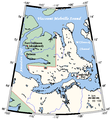
File:VictoriaIslandMap.png

All following user names refer to en.wikipedia.

  • 2006-03-25 03:16 Kelisi 504×540×8 (21 KB) (A map of Victoria Island in the Northwest Territories and Nunavut. This map's source is [http://www.aquarius.geomar.de/omc/make_map.html here], with the uploader's modifications, and the [http://gmt.soest.hawaii.edu/ GMT homepage] says that the tools are )

Captions

Add a one-line explanation of what this file represents

Items portrayed in this file

depicts

image/png

File history

Click on a date/time to view the file as it appeared at that time.

Date/TimeThumbnailDimensionsUserComment
current01:53, 31 January 2021Thumbnail for version as of 01:53, 31 January 2021504 × 540 (27 KB)KelisiOops! That was silly. Sorry, I'll try again..........
01:50, 31 January 2021Thumbnail for version as of 01:50, 31 January 2021504 × 540 (27 KB)KelisiInhabited hamlets' names have been rendered in bigger type (Fort Collinson has been left smaller), and the local name Ulukhaktok has replaced the former, English name Holman, since the article about the place now has that title.
11:32, 13 August 2008Thumbnail for version as of 11:32, 13 August 2008504 × 540 (21 KB)Telim tor== Information == {{Information |Description={{en|A map Victoria Island, Canada}} |Source=This map's source is [http://www.aquarius.ifm-geomar.de/ here], with the uploader's modifications, and the [http://gmt.soest.hawaii.edu/ GMT homepage] says that the

The following 3 pages use this file:

Global file usage

The following other wikis use this file:

Metadata