File:Viking Expansion.svg
[]
-
 català
 -
 English
 -
 español
 -
 français
 -
 português
 -
 한국어
한국어 -
 עברית
עברית -
 العربية
 -
 العربية 2
 -
 magyar
[]


| This work has been released into the public domain by its author, I, Max Naylor. This applies worldwide. In some countries this may not be legally possible; if so: I, Max Naylor grants anyone the right to use this work for any purpose, without any conditions, unless such conditions are required by law. |
Click on a date/time to view the file as it appeared at that time.
| Date/Time | Thumbnail | Dimensions | User | Comment | |
|---|---|---|---|---|---|
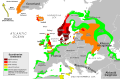
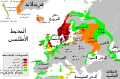
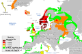
| current | 22:29, 25 February 2018 |  | 800 × 524 (2.92 MB) | Asmodim | Added the areas of the Norman "Kingdom of Africa" (see article on wikipedia), conquest part of the Norman kingdom of Sicily under Roger II. |
| 19:16, 15 August 2015 |  | 800 × 524 (1.4 MB) | Ras67 | frame removed | |
| 09:24, 21 May 2015 |  | 793 × 521 (1.39 MB) | Wereldburger758 | Removal modern state borders. Valid SVG now. | |
| 11:08, 3 December 2012 |  | 793 × 521 (1.93 MB) | OjdvQ9fNJWl | Fixed colors | |
| 10:43, 3 December 2012 |  | 793 × 521 (1.93 MB) | OjdvQ9fNJWl | Updated 11th century areas. Added Bari and Apulia in Italy, and renamed Spanish Kingdoms to Iberian Kingdoms. | |
| 20:38, 24 June 2007 |  | 793 × 521 (1.9 MB) | Max Naylor~commonswiki | == Summary == {{Information |Description=An SVG version of this image. Created with Adobe Illustrator CS3. Based on the blank Europe map available on the Commons. The enclosed legend is as follows: {{legend|#800000|eighth c | |
| 20:25, 24 June 2007 |  | 793 × 521 (1.25 MB) | Max Naylor~commonswiki | == Summary == {{Information |Description=An SVG version of this image. Created with Adobe Illustrator CS3. Based on the blank Europe map available on the Commons. The enclosed legend is as follows: {{legend|#800000|eighth c | |
| 20:20, 24 June 2007 |  | 793 × 521 (1.26 MB) | Max Naylor~commonswiki | == Summary == {{Information |Description=An SVG version of this image. Created with Adobe Illustrator CS3. Based on the blank Europe map available on the Commons. The enclosed legend is as follows: {{legend|#800000|eighth c | |
| 20:18, 24 June 2007 |  | 793 × 521 (1.26 MB) | Max Naylor~commonswiki | == Summary == {{Information |Description=An SVG version of this image. Created with Adobe Illustrator CS3. Based on the blank Europe map available on the Commons. The enclosed legend is as follows: {{legend|#800000|eighth c | |
| 20:16, 24 June 2007 | 2,443 × 682 (1.26 MB) | Max Naylor~commonswiki | {{Information |Description=An SVG version of this image. Created with Adobe Illustrator CS3. Based on the blank Europe map available on the Commons. The enclosed legend is as follows: {{legend|#800000|eighth centuries}} {{l |
The following other wikis use this file:
View more global usage of this file.