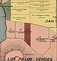
File:Walteria 1888.jpg
Rowan, V. J. (Valentine James) Schmidt Label & Litho. Co. Created / Published
San Francisco, Cal. : Schmidt Label & Litho. Co., 1888. Headings
- Los Angeles County (Calif.)--Maps - Real property--California--Los Angeles County--Maps - Landowners--California--Los Angeles County--Maps - United States--California--Los Angeles County Genre
Maps Cadastral maps Notes
- Relief shown by hachures. - Cadastral map showing drainage, roads, railroads, ranchos, township & section lines, land ownership, landowners' names, etc. - "Entered according to Act of Congress in the year 1888, by V.J. Rowan, in the office of the Librarian of Congress, at Washington, D.C." - Includes view of the Los Angeles County Court House and col. ill. - LC Land ownership maps, 23 - Available also through the Library of Congress Web site as a raster image. Medium
1 map on 8 sheets : hand col., cloth backing ; 179 x 151 cm. Call Number/Physical Location
G4363.L6 1888 .R6 Repository
Library of Congress Geography and Map Division Washington, D.C. 20540-4650 USA dcu Digital Id
http://hdl.loc.gov/loc.gmd/g4363l.la000023 Library of Congress Control Number
2012590104 Online Format
image LCCN Permalink
https://lccn.loc.gov/2012590104Licensing
This work is in the public domain in the United States because it was published (or registered with the U.S. Copyright Office) before January 1, 1929.
Public domain works must be out of copyright in both the United States and in the source country of the work in order to be hosted on the Commons. If the work is not a U.S. work, the file must have an additional copyright tag indicating the copyright status in the source country.
Note: This tag should not be used for sound recordings. |
