Click on a date/time to view the file as it appeared at that time.
| Date/Time | Thumbnail | Dimensions | User | Comment |
|---|
| current | 22:54, 30 December 2010 | 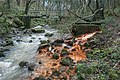 | 640 × 426 (112 KB) | GeographBot | == {{int:filedesc}} == {{Information |description={{en|1=Waytail Beck, Whitecliff Wood Waytail Beck looks clean however just before its confluence with Kilton Beck a run off from the Liverton Ironstone Mine shows obvious pollution. Although hazardous for |
The following pages on the English Wikipedia use this file (pages on other projects are not listed):
This file contains additional information, probably added from the digital camera or scanner used to create or digitize it.
If the file has been modified from its original state, some details may not fully reflect the modified file.
