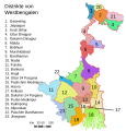
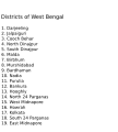
File:WestBengalDistricts Numbered.svg
Based on https://web.archive.org/web/20040606103522/www.censusindia.net/results/2001maps/wbengal01.html
Modifications by Mouryan:
- upladed translated version of File:WestBengalDistricts numbered de.svg.
- The districts of Dakshin 24 Parganas district and Uttar 24 Parganas were incorrectly numbered in the Map. The errors have been rectified.
Modifications by Furfur:
- The 4 (four) new districts of West Bengal namely Paschim Bardhaman district (bifurcated from Bardhaman district), Kalimpong district (bifurcated from Darjeeling district), Alipurduar district (bifurcated from Jalpaiguri district) and Jhargram district (bifurcated from Paschim Medinipur district) has been shown in this new Updated map.
Modifications by Antorjal:
- Midnapore District has been bifurcated to show both Paschim Medinipur and Purba Medinipur.
- Numbered and listed districts per comments at peer-review.
- Font size reduced for clarity, since the districts are now listed.
- Many of the spellings did not conform to linked articles in the text. All spellings now match the West Bengal article spellings.
[]
-
Assamese
-
English
-
English
-
Kannada
-
Bangla (2001)
-
Bangla
-
Bishnupriya
-
German
-
Gujarati
-
Malayalam
-
Santali
-
Telugu
-
Hindi
-
Odia
-
Punjabi
This W3C-invalid map was created with Adobe Illustrator,


