Click on a date/time to view the file as it appeared at that time.
| Date/Time | Thumbnail | Dimensions | User | Comment |
|---|
| current | 06:44, 11 January 2013 | 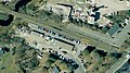 | 797 × 446 (75 KB) | Pi.1415926535 | {{Information |Description ={{en|1=Aerial view of Westbrook station in 2008, showing the old platform location and the town garage which was torn down in 2012}} |Source =USGS imagery via Google Earth |Author =United States Geological... |
The following pages on the English Wikipedia use this file (pages on other projects are not listed):
This file contains additional information, probably added from the digital camera or scanner used to create or digitize it.
If the file has been modified from its original state, some details may not fully reflect the modified file.
