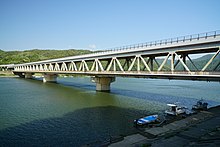
Gōnokawa River
The mainstream originates from Mount Asa (阿佐山) located in Kitahiroshima, Hiroshima (former Geihoku). Its three tributaries including Basen River (馬洗川), Saijō River (西城川) and Kannose River (神野瀬川) flows into the mainstream in Miyoshi Basin. The gradients being relatively gentle, the river had been commonly used for boat transport until 1930s, when Sankō Line and trafficways were built and opened. There are some valleys and waterfalls such as Senjōkei, Dangyokei and Jōsei Falls around the region of the river.
It is known for ukai (鵜飼い) or cormorant fishing for ayu, which can be found especially in Miyoshi. According to one theory ukai in Miyoshi has taken place since late Sengoku Period, and is now one of the tourist attractions of the city.
Communities


The river and its tributaries pass through or borders eight cities and seven towns that are located in Shimane Prefecture and Hiroshima Prefecture as is shown below. As of 2000 according to the national census 278,207 people lived in the drainage basin, including 104,169 from Shimane and 174,038 from Hiroshima.
- Hiroshima Prefecture
- Kitahiroshima, Akitakata, Higashihiroshima, Sera, Jinsekikogen, Fuchu, Shōbara, Miyoshi
- Shimane Prefecture
- Ōnan, Misato, Iinan, Kawamoto, Ōda, Hamada, Gōtsu
Dams

Major dams located within the basin are shown below.
- Haji Dam - located in Akitakata, Hiroshima. Water in the reservoir is supplied to Ōta River that flows into Seto Inland Sea through a tunnel under the dividing ridge. The reservoir is selected as Selected 100 Dam Lakes of Japan, and the lakeside is noted for the cherry blossoms.
- Kōbo Dam - located on Kannose River, one of the tributaries, in Takano, Hiroshima.
- Kutsugahara Dam - located on Kannose River in Kimita, Hiroshima.
- Haizuka Dam - located on Jōge River (上下川), one of the tributaries, in Mirasaka, Hiroshima.
- Hamahara Dam - located in Misato, Shimane.
Notes
- ^ Average from 1957 to 2003.
- ^ According to Encyclopedia Nipponica, the basin size of the river is 3,870 km (1,490 sq mi).
- ^ Population as of 2000 based on the national census.
- References
- ^ "江の川(ゴウノガワ)とは - コトバンク" (in Japanese). kotobank. Retrieved January 2, 2018.
- ^ "江の川" (in Japanese). Ministry of Land, Infrastructure, Transport and Tourism. Retrieved January 2, 2018.
- ^ "阿佐山(あさやま)とは - コトバンク" (in Japanese). kotobank. Retrieved January 2, 2018.
- ^ "江の川水系の流域及び河川の概要" (PDF) (in Japanese). Ministry of Land, Infrastructure, Transport and Tourism. pp. 1, 22, 28, 53. Retrieved January 3, 2018.
- ^ "江の川" [Gōnokawa River]. Nihon Rekishi Chimei Taikei (in Japanese). Tokyo: Shogakukan. 2012. OCLC 173191044. dlc 2009238904. Archived from the original on 2007-08-25. Retrieved 2012-09-11.
- ^ "日本の川 - 中国 - 江の川 - 国土交通省水管理・国土保全局" (in Japanese). Ministry of Land, Infrastructure, Transport and Tourism. Retrieved January 3, 2018.
- ^ "日本の川 - 中国 - 江の川 - 国土交通省水管理・国土保全局 江の川の歴史" (in Japanese). Ministry of Land, Infrastructure, Transport and Tourism. Retrieved January 3, 2018.
- ^ "常清滝(ジョウセイダキ)とは - コトバンク" (in Japanese). kotobank. Retrieved January 3, 2018.
- ^ "三次の鵜飼 三次市観光公式サイト" (in Japanese). Miyoshi City. Retrieved January 3, 2018.
- ^ "土師ダム 都市用水の供給" (in Japanese). Ministry of Land, Infrastructure, Transport and Tourism. Retrieved January 3, 2018.
- ^ "ダムの書誌あれこれ(90)~江の川土師ダム、太田川高瀬堰~" (in Japanese). Japan Dam Foundation. Retrieved January 3, 2018.
- ^ "八千代湖「土師ダム」 ダム湖百選" (in Japanese). Water Resources Environment Center, Japan. Retrieved January 3, 2018.
- ^ "高暮ダム[広島県] - ダム便覧" (in Japanese). Japan Dam Foundation. Retrieved January 3, 2018.
- ^ "沓ヶ原ダム[広島県] - ダム便覧" (in Japanese). Japan Dam Foundation. Retrieved January 3, 2018.
- ^ "灰塚ダム[広島県] - ダム便覧" (in Japanese). Japan Dam Foundation. Retrieved January 3, 2018.
- ^ "浜原ダム[島根県] - ダム便覧" (in Japanese). Japan Dam Foundation. Retrieved January 3, 2018.