Gray Whiskers
Description
Gray Whiskers is situated 1.6 miles (2.6 km) southwest of the Monument Valley visitor center on Navajo Nation land and can be seen from Highway 163. Precipitation runoff from this butte's slopes drains to Mitchell Butte Wash and Oljeto Wash which are part of the San Juan River drainage basin. Topographic relief is significant as the summit rises over 800 feet (244 meters) above the surrounding terrain in 0.15 mile (0.24 km). The nearest higher neighbor is Mitchell Mesa, 1.5 miles (2.4 km) to the east. The landform's toponym has been officially adopted by the U.S. Board on Geographic Names. The toponym is a translation of Navajo "dághaa' libáí" which means gray whiskers. The butte is named after a Navajo Hataałii (medicine man) who was instrumental in creating the Monument Valley Tribal Park in 1958.
Geology
Gray Whiskers is composed of three principal strata. The bottom layer is slope-forming Organ Rock Shale, the next stratum is cliff-forming De Chelly Sandstone, and the upper layer is Moenkopi Formation. The rock ranges in age from Permian at the bottom to Triassic at the top. The buttes and mesas of Monument Valley are the result of the Organ Rock Shale being more easily eroded than the overlaying sandstone.
Climate
Spring and fall are the most favorable seasons to visit Gray Whiskers. According to the Köppen climate classification system, it is located in a semi-arid climate zone with cold winters and hot summers. Summers average 54 days above 90 °F (32 °C) annually, and highs rarely exceed 100 °F (38 °C). Summer nights are comfortably cool, and temperatures drop quickly after sunset. Winters are cold, but daytime highs are usually above freezing. Winter temperatures below 0 °F (−18 °C) are uncommon, though possible. This desert climate receives less than 10 inches (250 millimeters) of annual rainfall, and snowfall is generally light during the winter.
Gallery
-
 Northeast aspect
 -
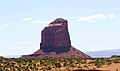
 Gray Whiskers to right, next to the broader Mitchell Mesa at far right.
View is from WSW along Highway 163. -
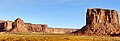 Gray Whiskers to left with Mitchell Mesa behind, and Mitchell Butte to the right.
 -
 Gray Whiskers from the visitor center
 -
 Gray Whiskers to right with the broader Mitchell Mesa to left
 -
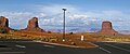 The view from Monument Valley Visitor Center parking lot looking west-southwest at Gray Whiskers (left) and Mitchell Butte (right).


.jpg)

See also
References
- ^ "Gray Whiskers - 6,385' AZ". listsofjohn.com. Retrieved 2024-08-27.
- ^ "Gray Whiskers". Geographic Names Information System. United States Geological Survey, United States Department of the Interior. Retrieved 2024-08-27.
- ^ First Ascent Timeline, deserttowersbook.com, Retrieved 2024-08-27.
- ^ William Bright, Native American Placenames of the United States, University of Oklahoma Press, 2004, ISBN 9780806135984, p. 157.
- ^ Monument Valley, City of Aztec, aztecnm.com, Retrieved 2024-08-27.
- ^ Guiding tourists in Monument Valley, Los Angeles Times, July 28, 2014.
- ^ Geology and Uranium-vanadium Deposits of the Monument Valley Area, Apache and Navajo Counties, Arizona, Irving Jerome Witkind, U.S. Government Printing Office, 1963, p. 139.
- ^ Monument Valley, Arizona, Arizona Geological Survey, Retrieved 2024-08-27.
- ^ Climate Summary for Kayenta, Arizona
External links
- Weather forecast: Gray Whiskers
- Gray Whiskers (photo): Flickr
- Monument Valley Tribal Park
Places adjacent to Gray Whiskers | ||||||||||||||||
|---|---|---|---|---|---|---|---|---|---|---|---|---|---|---|---|---|
| ||||||||||||||||