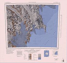
Hayes Head
Geography

Wood Bay is on the west coast of the Ross Sea. It is delimited to the north by Hayes Head on Cape Johnson. The Aviator Glacier Tongue extends into the sea between Wood Bay and Lady Newnes Bay to the north. The Tinker Glacier Tongue extends into the bay to the east of Cape Johnson and Kay Island, and to the west of Harrow Peaks in the Random Hills. Further south is Edmonson Point, where there is an Adélie penguin rookery, Willows Nunatak and Cape Washington, which delimited the south end of the bay. Mount Melbourne dominates the southern part of the bay.
Features
Named features of the bay, from north to south, include:
Hayes Head
74°01′S 165°17′E / 74.017°S 165.283°E. A prominent headland, 850 metres (2,790 ft) high, overlooking the north extremity of Wood Bay, standing 3 nautical miles (5.6 km; 3.5 mi) north of Kay Island. Mapped by the United States Geological Survey (USGS) from surveys and United States Navy air photos, 1955-63. Named by the United States Advisory Committee on Antarctic Names (US-ACAN) for Miles O. Hayes, geologist at McMurdo Station, 1965-66 season.
Cape Johnson
74°04′S 165°09′E / 74.067°S 165.150°E. An ice-covered cape in northern Wood Bay at the east side of the terminus of Tinker Glacier. Discovered in 1841 by Captain James Clark Ross, Royal Navy who named it for Captain Edward John Johnson, RN.
Kay Island
74°04′S 165°19′E / 74.067°S 165.317°E. A small island lying 2 nautical miles (3.7 km; 2.3 mi) east of Cape Johnson in the north part of Wood Bay. Discovered in 1841 by Captain James Clark Ross, and named by him for Lieutenant Joseph W. Kay, Dir. of the Rossbank Observatory in Tasmania, who was third lieutenant on the ship Terror. Originally charted by Ross as a group of three islands, only this one is now known to exist.
Edmonson Point
74°20′S 165°08′E / 74.333°S 165.133°E. A rounded, largely ice-free point lying below Mount Melbourne along the west side of Wood Bay. Mapped by USGS from surveys and United States Navy air photos, 1955-63. Named by US-ACAN for Larry D. Edmonson, satellite geodesy scientist at McMurdo Station, winter party 1966.
Willows Nunatak
74°29′S 165°17′E / 74.483°S 165.283°E. A nunatak standing 1 nautical mile (1.9 km; 1.2 mi) inland from the south shore of Wood Bay, rising above the col between Cape Washington and Mount Melbourne. Mapped by USGS from surveys and United States Navy air photos, 1955-63. Named by US-ACAN for A.O. Dennis Willows, biologist at McMurdo Station, summer 1965-66.

Cape Washington
74°39′S 165°25′E / 74.650°S 165.417°E. A prominent cape, 275 metres (902 ft) high, marking the south extremity of the peninsula which separates Wood Bay and Terra Nova Bay. Discovered in 1841 by Captain James Clark Ross, and named by him for Captain John Washington, Royal Navy, who was secretary of the Royal Geographical Society, 1836-40.
References
- ^ Alberts 1995, p. 822.
- ^ Mount Melbourne.jpg USGS.
- ^ Coulman Island USGS.
- ^ Alberts 1995.
- ^ Alberts 1995, p. 374.
- ^ Alberts 1995, p. 384.
- ^ Alberts 1995, p. 212.
- ^ Alberts 1995, p. 816.
- ^ Alberts 1995, p. 796.
Sources
- Alberts, Fred G., ed. (1995), Geographic Names of the Antarctic (PDF) (2 ed.), United States Board on Geographic Names, retrieved 2024-01-25
 This article incorporates public domain material from websites or documents of the United States Board on Geographic Names.
 - Coulman Island, USGS: United States Geological Survey, retrieved 2024-01-25
- Mount Melbourne.jpg, USGS: United States Geological Survey, retrieved 2024-01-27
![]() This article incorporates public domain material from websites or documents of the United States Geological Survey.
This article incorporates public domain material from websites or documents of the United States Geological Survey.