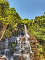
Honnammana Halla Falls
Attigundi is a village in the Chikkamagalur district of Karnataka. It is governed locally by gram panchayat. It is located near the Muthodi wildlife sanctuary and the tourist destinations of Honnammana Halla waterfalls, Jhari Falls, Kavikal Gandi, Galikere, Bababudangiri and Kemmangundi. The average temperature is 20 degrees Celsius.
-
 Manikyadhara falls on Baba Budangiri near Attigundi
 -
 Jhari falls


| Climate data for Attigundi | |||||||||||||
|---|---|---|---|---|---|---|---|---|---|---|---|---|---|
| Month | Jan | Feb | Mar | Apr | May | Jun | Jul | Aug | Sep | Oct | Nov | Dec | Year |
| Mean daily maximum °C (°F) | 26.5 (79.7) |
28.2 (82.8) |
30.3 (86.5) |
30.3 (86.5) |
28.0 (82.4) |
23.6 (74.5) |
22.2 (72.0) |
22.6 (72.7) |
24.0 (75.2) |
24.6 (76.3) |
24.5 (76.1) |
25.2 (77.4) |
25.8 (78.5) |
| Mean daily minimum °C (°F) | 14.1 (57.4) |
15.3 (59.5) |
17.4 (63.3) |
19.3 (66.7) |
19.5 (67.1) |
18.9 (66.0) |
18.3 (64.9) |
18.1 (64.6) |
17.9 (64.2) |
17.4 (63.3) |
15.9 (60.6) |
14.5 (58.1) |
17.2 (63.0) |
| Average rainfall mm (inches) | 5 (0.2) |
8 (0.3) |
18 (0.7) |
56 (2.2) |
112 (4.4) |
217 (8.5) |
264 (10.4) |
201 (7.9) |
143 (5.6) |
175 (6.9) |
65 (2.6) |
15 (0.6) |
1,279 (50.3) |
| Source: https://en.climate-data.org/asia/india/karnataka/attigundi-757050/ | |||||||||||||
References
- ^ "Attigundi, Chikmagalur, Mysore, India on the Elevation Map. Topographic Map of Attigundi, Chikmagalur, Mysore, India".
- ^ "NREGA (MGNREGA) in Attigundi (CHIKMAGALUR) chickmagalur District, karnataka - Nrega". Archived from the original on 13 April 2017. Retrieved 12 April 2017.
- ^ "Man attacked by tiger". The Hindu. 2 October 2013.
- ^ "'Fence around Galikere unscientific'". February 2019.
- ^ "Hindu activists hoist saffron flag, cops resort to lathi-charge at Bababudangiri". 4 December 2017.
- ^ "Indian Journal of Earth Sciences". 1982.
- ^ "One more weapon found in Kemmanagundi area, more arrests likely".
- ^ "Attigundi climate: Average Temperature, weather by month, Attigundi weather averages - Climate-Data.org". en.climate-data.org. Retrieved 26 December 2021.
This article related to a location in Chikkamagaluru district, Karnataka, India is a stub. You can help Wikipedia by expanding it. |