Ilhéu Das Rolas
| Year | Pop. | ±% |
|---|---|---|
| 2001 | 224 | — |
| 2008 | 255 | +13.8% |
| 2012 | 76 | −70.2% |


History
The island was mentioned as "Illie de Rolle" in a 1665 map by Johannes Vingboons. and as "I. de Rolle" in a 1780 map by A. Dalrymple.
Gago Coutinho (1869–1959), officer of the Portuguese Navy, navigator and historian, headed a geodesic mission to São Tomé between 1915 and 1918, when marks were placed as a basis for a geodetic network in the archipelago. After that, observations for triangulation, precise base measurement and astronomical observations were made.
In the process, Gago Coutinho proved that Ilhéu das Rolas is crossed by the equatorial line. The resulting map was published in 1919, together with the Report of the Geodetic Mission on São Tomé Island 1915–1918, that was officially considered the first complete work of practical geodesy in the Portuguese colonies.
Nature
The islet is abundant in flora and fauna. Some endemic species are Greeff’s giant gecko, birds such as the São Tomé prinia and the São Tomé weaver and frogs such as Phrynobatrachus leveleve and Schistometopum thomense.
Gallery
-
 Praia de Santo António
 -
 Beach scenery in São Tomé and Príncipe
 -
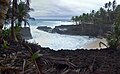
 Ilhéu das Rolas, STP
 -
 Ilhéu das Rolas
 -
 São Tomé and Príncipe
 -
 STP
STP -
 Beach close to Ilhéu das Rolas, São Tomé and Príncipe
 -
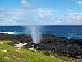 Furnas, a blowhole in Rolas
.jpg)

.jpg)
.jpg)

.jpg)
.jpg)

References
- ^ Sailing Directions (Enroute), Pub. 123: Southwest Coast of Africa (PDF). Sailing Directions. United States National Geospatial-Intelligence Agency. 2017. p. 76.
- ^ 2012 detailed census São Tomé e Príncipe Archived 2019-03-27 at the Wayback Machine, Instituto Nacional de Estatística
- ^ Rowlett, Russ. "Lighthouses of São Tomé and Príncipe". The Lighthouse Directory. University of North Carolina at Chapel Hill.
- ^ List of Lights, Pub. 113: The West Coasts of Europe and Africa, the Mediterranean Sea, Black Sea and Azovskoye More (Sea of Azov) (PDF). List of Lights. United States National Geospatial-Intelligence Agency. 2018. p. 442.
- ^ "Evolução da população São-Tomense por localidades, 2001/2007-08" (PDF). Instituto Nacional de Estatística. Archived from the original (PDF) on 2017-02-09.
- ^ 1665 map of the island of São Tomé by Johannes Vingboons, now at the Dutch National Archive
- ^ 1780 map of the island of São Tomé by T. Harmar and A. Dalrymple, now at the French National Library
- ^ Hemidactylus greeffii at the Reptarium.cz Reptile Database. Accessed 2018-02-13.
| Major islands | |
|---|---|
| Minor islands and islets | |
| Settlements |  | |
|---|---|---|
| Geographical features | ||
| Culture | ||