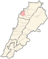
Kfaraakka
Kfaraakka produces and exports the most olive oil in Lebanon. It is about 350 meters above sea level, It has two hills: Mar Youhanna Hill, and Mar Nohra Hill. It is 17 kilometres from the coastal city of Tripoli and 11 kilometres from Chekka.
Etymology
The village of Kfaraakka derives its name from the Aramaic language, composed of two words: Kafar and Aka. “Kafar” means village and "Aka" means sorrow, so the meaning of Kfaraakka is the village of sadness, gloom and distress.
Religion
The vast majority of inhabitants of Kfaraakka are Christians, with roughly 92% Greek Orthodox and 8% Maronite/Greek Catholic.
Churches
- Anastasis Cathedral – Greek Orthodox.
- St. Georges – Greek Orthodox.
- St. Nohra – Greek Orthodox.
- St. Mary – Greek Orthodox.
- St. John The Baptist - Greek Orthodox.
- St. Simeon monastery - Greek Orthodox.
- St. Lucas - Greek Orthodox.
- St. Georges – Maronite.
Education
There are two official complementary schools in Kfaraakka, one for males and one for females, a mixed public high school, a private professional institute (Freddy Atallah - IFA) and a branch of the American University for Culture and Education (AUCE).
Street names
As of 2017, Kfaraakka has 10 named streets
- Al Biyad
- Al Seha
- Al Matriyeh
- Al Ramieh
- Dahr Al Mazraa
- Fouk Al Bir
- Mar Nohra
- Mar Youhanna
- Tahta
- Talaa
History
Ottoman Era
In 1519, at the beginning of the Ottoman Era in Lebanon, the village was home to 67 adult Christian males and 4 adult Muslim ones. By 1571, the population had increased to 95 adult Christian males, though with only 3 adult Muslim males by this point.
French Occupation
The relationship with the French army was unstable. Many problems occurred between Kfarakka Citizens and the Algerians, Senegalese and Moroccans inductees in the French army. General de Gaulle has visited Kfarakka several times, especially the area of “Al Bader”, to meet the French soldiers.
1976-1978
Between 1976 and 1978, Kfarakka was under the control of the Lebanese Front.
1978-2005
From 1978 until the withdrawal of the Syrian army, Kafaraka was part of the Syrian-controlled areas in Lebanon.
On 11 July 1984, pro-Syrian Marada Militia ousted SSNP and took control of Kfarakka until the end of the civil war in 1990.
Municipal elections
2010 municipal election
Municipal election was held on 30 May 2010. Election was held for 15 seats in the municipal council of the village.
The two contending lists were "Kafaraka solidarity and development" headed by Fares Massaad Boulos and backed by 14 March, "Kafaraka for all" headed by Rodolph Matar and backed by 8 March.
On 1 June 2010, it was announced that 14 March won 15-0.
2016 municipal election
Municipal election was held on 29 May 2016. Election was held for 15 seats in the municipal council of the village.
3,539 were eligible to vote but only 1,871 (53%) voted.
The two contending lists were "Kafaraka brings us together" headed by Elias Sassine and backed by the Lebanese Forces, Tayyar and Kataeb, "Kafaraka is my town and my belonging" headed by Philipe Fares Boulos and backed by Marada, SSNP and Deputy Speaker Farid Makari.
The first list (Kafaraka brings us together) won 10 seats and received an average of 899 votes (48%) while the second list won 5 seats and received an average of 839 votes (44.8%).
Notable People
References
- ^ "Municipal and ikhtiyariah elections in Northern Lebanon" (PDF). The Monthly. March 2010. p. 23. Archived from the original on 3 June 2016. Retrieved 31 October 2016.
{{cite web}}: CS1 maint: bot: original URL status unknown (link) - ^ "HOUSEHOLD INCOME AND EXPENDITURE IN AL-KURA, LEBANON" (PDF). 2023-03-24. Archived from the original on 2023-03-24. Retrieved 2023-03-25.
{{cite web}}: CS1 maint: bot: original URL status unknown (link) - ^ "الوكالة الوطنية للإعلام - بلدة كفرعقا الكورانية الاولى في انتاج الزيت وتصديره ايقونة كنيسة رقاد السيدة "ام النور" نضحت زيتا سنة 1957".
- ^ "The Location".
- ^ "The name".
- ^ "إميل بديع بعقوب - المكتبة الشاملة الحديثة".
- ^ "مسيحيو الروم الارثوذكس اللبنانيون".
- ^ "Anastasis Cathedral - Kafaraka".
- ^ "St. Georges - Kafaraka".
- ^ "St. Mary - Kafaraka".
- ^ "St. Nohra - Kafaraka".
- ^ "St. John The Baptist - Kafaraka".
- ^ "St. Simeon monastery - Kafaraka".
- ^ "St. Lucas - Kafaraka".
- ^ "Institut Freddy Atallah (IFA), Main Street, Kfar Aaqqa (2022)".
- ^ "Auce Koura Page - Kfar Aaqqa 🇱🇧 - WorldPlaces".
- ^ "Street naming and numbering". 15 December 2017.
- ^ "SURVEY OF THE SYRIAN REFUGEES". 2 July 2019.
- ^ "During Ottoman's Period". Kafaraka. Retrieved 8 December 2024.
- ^ "Political development after World War I".
- ^ "Political development after World War I".
- ^ Hijazi, Ihsan A. (13 July 1984). "RIVAL PRO-SYRIAN FACTIONS CONTINUE BATTLE IN NORTH LEBANON". The New York Times.
- ^ "المردة والكورة مداهم الحيوي".
- ^ "النتائج الأولية غير الرسمية للإنتخابات البلدية والإختيارية في قضاء الكورة". 30 May 2010.
- ^ "اعلان لوائح بلدية في كفرعقا". 24 May 2010.
- ^ "اعلان لائحة كفرعقا للجميع".
- ^ "النتائج المفصلة للإنتخابات البلدية في قضاء الكورة: فوز 14 آذار بالأكثرية". June 2010.
- ^ "انتخابات بلدية كفرعقا".
- ^ "الوطني الحرّ يدعم كفرعقا بتجمعنا".
- ^ "القوات تدعم لائحة كفرعقّا بتجمعنا برئاسة الياس ساسين". 27 May 2016.
External links
- Kfar Aaqqa Archived 2016-11-01 at the Wayback Machine, Localiban
- The municipality of Kafaraka [1]
