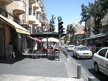
King George Street (Jerusalem)
History
King George Street was dedicated in honour of the seventh anniversary of the British conquest of Jerusalem under General Allenby. The inauguration took place in 1924, in the presence of Sir Herbert Samuel, the High Commissioner for Palestine, Sir Ronald Storrs, the military governor of Jerusalem, and Raghib al-Nashashibi, the Arab mayor of Jerusalem.

Jerusalem's first traffic light was installed at the intersection of King George Street and Jaffa Road. In 1950–1966, the Knesset, Israel's parliament, met at Beit Froumine on King George Street. It was used by Israel's first five governments, until the Knesset moved to a permanent building in Givat Ram.
Until the advent of the Jerusalem Light Rail, King George Street was one of two Jerusalem streets with a pedestrian scramble; the other is Kikar HaShabbat.
Landmarks
- Great Synagogue and Heichal Shlomo
- Jewish Agency for Israel
- Beit HaMa'alot ("elevator house"), 1935 highrise building with elevator, architects Alexander Friedman and Meir Rubin
- Beit Avi Chai culture centre and Art Gallery
- The National Institutions House
- Independence Park
- Shiber Pit, the former Menorah Garden – the small park with the bronze horse statue at the junction with Ben Yehuda Street.
See also
- King George Street (Tel Aviv)
- 1984 King George Street attack
- Sbarro restaurant suicide bombing
- King George Street bombing
References
- ^ Neighborhoods in brief
- ^ About King George Street
- ^ A Walk Across Jerusalem History, Haaretz
- ^ Miller, Rory (2000). "Sir Ronald Storrs and Zion: the dream that turned into a nightmare". Middle Eastern Studies. 36 (3): 114–144. JSTOR 4284094.
- ^ "King George Street in Jerusalem". Archived from the original on 2017-06-23. Retrieved 2010-11-08.
- ^ Haman's Hat: Life in the Jerusalem Triangle
- ^ Beit Froumine
- ^ Bar-Am, Aviva (25 December 2008). "Walking Tour: By George!". Jerusalem Post.
Gallery
-
Commemorative plaque on King George Street
-
Dedication of the street in 1924
-
Construction of high-rise building on King George Street, 1940
-
The carillon of the shopping center at the beginning of the street
31°46.892′N 35°12.988′E / 31.781533°N 35.216467°E


