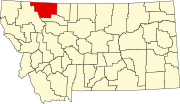
Kiowa, Montana
Kiowa, is an unincorporated community in Glacier County, Montana, United States. Its elevation is 5,076 feet (1,547 m) and is located at the intersection of U.S. Route 89 and Highway 49, 12 miles (19 km) west of Browning, near Glacier National Park.
Climate
This climatic region is typified by large seasonal temperature differences, with warm to hot (and often humid) summers and cold (sometimes severely cold) winters. According to the Köppen Climate Classification system, Kiowa has a humid continental climate, abbreviated "Dfb" on climate maps.
| Climate data for Kiowa, Montana: 4,929 ft (1,502 m) | |||||||||||||
|---|---|---|---|---|---|---|---|---|---|---|---|---|---|
| Month | Jan | Feb | Mar | Apr | May | Jun | Jul | Aug | Sep | Oct | Nov | Dec | Year |
| Record high °F (°C) | 56 (13) |
63 (17) |
70 (21) |
80 (27) |
86 (30) |
89 (32) |
97 (36) |
93 (34) |
92 (33) |
86 (30) |
67 (19) |
53 (12) |
97 (36) |
| Mean daily maximum °F (°C) | 31.9 (−0.1) |
33.9 (1.1) |
39.7 (4.3) |
47.5 (8.6) |
58.1 (14.5) |
66.6 (19.2) |
74.3 (23.5) |
74.2 (23.4) |
63.1 (17.3) |
52.0 (11.1) |
37.0 (2.8) |
30.2 (−1.0) |
50.7 (10.4) |
| Daily mean °F (°C) | 22.6 (−5.2) |
24.1 (−4.4) |
29.2 (−1.6) |
37.2 (2.9) |
46.3 (7.9) |
53.6 (12.0) |
59.7 (15.4) |
59.0 (15.0) |
49.8 (9.9) |
41.0 (5.0) |
28.7 (−1.8) |
21.5 (−5.8) |
39.4 (4.1) |
| Mean daily minimum °F (°C) | 13.2 (−10.4) |
14.3 (−9.8) |
18.7 (−7.4) |
26.9 (−2.8) |
34.5 (1.4) |
40.9 (4.9) |
45.1 (7.3) |
43.9 (6.6) |
36.5 (2.5) |
30.0 (−1.1) |
20.3 (−6.5) |
12.9 (−10.6) |
28.1 (−2.2) |
| Record low °F (°C) | −35 (−37) |
−44 (−42) |
−33 (−36) |
−7 (−22) |
16 (−9) |
25 (−4) |
30 (−1) |
18 (−8) |
8 (−13) |
−12 (−24) |
−26 (−32) |
−42 (−41) |
−44 (−42) |
| Average precipitation inches (mm) | 3.2 (81) |
2.5 (64) |
2.3 (58) |
2.1 (53) |
2.6 (66) |
3.0 (76) |
1.5 (38) |
1.6 (41) |
1.8 (46) |
1.7 (43) |
3.0 (76) |
2.9 (74) |
28.2 (720) |
| Average snowfall inches (cm) | 33.5 (85) |
27.4 (70) |
24.3 (62) |
17.8 (45) |
4.3 (11) |
0.7 (1.8) |
0.0 (0.0) |
0.2 (0.51) |
2.6 (6.6) |
8.3 (21) |
22.7 (58) |
30.4 (77) |
172.2 (437) |
| Source: | |||||||||||||
References
- ^ "Kiowa, Montana Köppen Climate Classification (Weatherbase)". Weatherbase. Retrieved January 9, 2024.
- ^ "Kiowa, Montana Travel Weather Averages (Weatherbase)". Weatherbase. Retrieved January 9, 2024.
