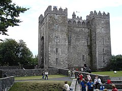
Lower Bunratty
Legal context
Baronies were created after the Norman invasion of Ireland as divisions of counties and were used the administration of justice and the raising of revenue. While baronies continue to be officially defined units, they have been administratively obsolete since 1898. They are still used in land registration and specification for planning permissions. In many cases, a barony corresponds to an earlier Gaelic túath which had submitted to the Crown.
Landscape
Bunratty Lower is a division of the former barony of Bunratty. This belonged to the Macnamara family, and was called Dangan-i-vigin. It is bounded by the barony of Bunratty Upper (to the north) and by the barony of Tulla Lower (to the east). To the south, the River Shannon separates it from County Limerick. To the west, the River Fergus separates it from the baronies of Clonderalaw and Islands. The barony covers an area of 69,083 acres (27,957 ha), of which 11,623 acres (4,704 ha) are tideway. The land is rocky and supports many sheep.
-
Baronies of Clare. Bunratty Lower is in the southeast.
Parishes and settlements
Bunratty Lower contains the parishes of Bunratty, Clonloghan, Drumline, Feenagh, Kilconry, Kilfinaghta, Kilfintinan, Kilmaleery, Kilmurry, Kilnasoolagh and Tomfinlough, as well as part of the parishes of Killeely, St. Munchin's and St. Patrick’s. The main towns are Newmarket-on-Fergus and Sixmilebridge.
Facilities and attractions
References
Citations
- ^ "Bun Raite Íochtarach/Bunratty Lower". Placenames Database of Ireland. Retrieved 20 November 2023.
- ^ Parliamentary Gazetteer of Ireland 1845.
Sources
- "Barony of Bunratty (Lower and Upper)". Parliamentary Gazetteer of Ireland. 1845. Retrieved 9 March 2014.

