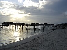
Mabul Island
The island is roughly 15 km north of Sipadan, 0.2km in size, and around 2–3m above sea level. It is located on the northwest of a reef that is ~2 km long.
Mabul island is administered as a part of the Semporna, Tawau district.
Native settlements
The two main settlements on the island are Kampung Mabul and Kampung Musu. The 1999 census recorded approximately 2,000 villagers living in Mabul; half of their children are under 14 years of age. The majority are immigrants from a chain of islands in the southern Philippines. These residents are mainly Bajau Laut and Suluk Muslims who live a nomadic lifestyle.
Basic amenities include a mosque, schools, community and fishermen's hall. The main transportation mode between places is via boat.
As most residents mainly work as fishermen, the village's source of income depends on ocean-based products such as squid and fish. Traditional fishing methods are called "Payau" and "Sangkaliya". Mabul fishers prefer fishing close to the Malaysia–Philippine border, perhaps due to the abundance of fish stocks. An average fishing trip will take 3 to 5 days out at sea. When they return, their catches are sold at Semporna on the mainland.
As of 2020, the population of Mabul is around 2,000.
Sea life and the reef

Mabul's reef is on the edge of the continental shelf, and the seabed surrounding the reef slopes out to a depth of 25–30m.
Flamboyant cuttlefish, blue-ringed octopus, mimic octopus, and bobtail squids are common cephalopods found in the Mabul reef. Frogfish are prevalent; giant, painted, and clown frogfish are regularly seen along with most of the scorpion fish family.
See also
References
- ^ "Sipadan Island". www.malaysia.travel. Retrieved 19 July 2023.
- ^ "Kampung Mabul's Bajau Laut at Pulau Mabul in Sabah, Malaysia". Rolling Grace - Asia Travel & Food Guide. Retrieved 18 May 2022.
- ^ Jereb (2005). CEPHALOPODS OF THE WORLD. ISBN 92-5-105383-9.
- ^ Sipadan, Mabul Kapali, - Sabah's underwater treasure, published by Natural History Publications.