Manx Peak
History
The peak was named in 1916 by Morrison P. Bridgland because the shape of the contours of the mountain resemble the triskelion in the flag of the Isle of Man, the home of the Manx people. Bridgland (1878–1948), was a Dominion Land Surveyor who named many peaks in Jasper Park and the Canadian Rockies.
The first ascent of Manx Peak was made in 1919 by R.T. Chamberlin and B. Herzberg.
This mountain's toponym was officially adopted in 1951 by the Geographical Names Board of Canada.
Climate
Based on the Köppen climate classification, Manx Peak is located in a subarctic climate zone with cold, snowy winters, and mild summers. Winter temperatures can drop below −20 °C (−4 °F) with wind chill factors below −30 °C (−22 °F). Precipitation runoff from Manx Peak drains into tributaries of the Athabasca River.
Gallery
-
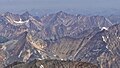
 Terminal Mountain (left) and Manx Peak (upper right) seen from The Whistlers
 -
 Terminal Mountain (left) and Manx Peak
 -
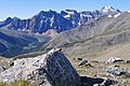
 South aspect of Manx Peak centered at top, viewed from Mt. Edith Cavell


See also
References
- ^ "Manx Peak". Bivouac.com. Retrieved 2019-03-31.
- ^ "Topographic map of Manx Peak". opentopomap.org. Retrieved 2023-08-16.
- ^ "Manx Peak". Geographical Names Data Base. Natural Resources Canada. Retrieved 2019-03-31.
- ^ Gadd, Ben (2008), Geology of the Rocky Mountains and Columbias
- ^ Place-names of Alberta. Ottawa: Geographic Board of Canada. 1928. p. 84.
- ^ MacLaren, I.S. (2005). Mapper of Mountains M.P. Bridgland in the Canadian Rockies 1902-1930. With Eric Higgs, Gabrielle Zezulka-Mailloux. Edmonton, AB: The University of Alberta Press. ISBN 0-88864-456-6.
- ^ Peel, M. C.; Finlayson, B. L.; McMahon, T. A. (2007). "Updated world map of the Köppen−Geiger climate classification". Hydrol. Earth Syst. Sci. 11: 1633–1644. ISSN 1027-5606.
External links
- Parks Canada web site: Jasper National Park
- Manx Peak: weather