Missouri Highway 133
Route 133 is a highway in central Missouri. Its northern terminus is at U.S. Route 63 near Westphalia; its southern terminus is at Interstate 44 about fourteen miles (21 km) west of Waynesville.
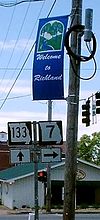
The intersection between MO 113 and MO 7 in Richland.
Highway 133 passes through Richland, where the highway intersects with Route 7.
Major intersections
| County | Location | mi | km | Destinations | Notes | |||
|---|---|---|---|---|---|---|---|---|
| Pulaski | Gascozark | 0.000 | 0.000 | exit 145 | ||||
| Laclede |
No major junctions | |||||||
| Pulaski | Richland | 6.532 | 10.512 | Southern end of Route 7 overlap | ||||
| 7.670 | 12.344 | Northern end of Route 7 overlap | ||||||
| Tavern Township | 17.902 | 28.810 | Southern end of Route 17 overlap | |||||
| 20.748 | 33.391 | Northern end of Route 17 overlap | ||||||
| Maries | Boone Township | 43.504 | 70.013 | Southern end of Route 42 overlap | ||||
| 43.725 | 70.369 | Northern end of Route 42 overlap | ||||||
| 53.970 | 86.856 | |||||||
| Osage | Meta | 56.214 | 90.468 | |||||
| Jackson Township | 58.684 | 94.443 | ||||||
| Washington Township | 71.160 | 114.521 | ||||||
1.000 mi = 1.609 km; 1.000 km = 0.621 mi
| ||||||||
References
KML is not from Wikidata
- ^ Missouri Department of Transportation (December 19, 2020). MoDOT HPMAPS (Map). Missouri Department of Transportation. Retrieved December 19, 2020.

This Missouri road-related article is a stub. You can help Wikipedia by expanding it. |