Mist Mountain
Mist Mountain is a mountain located alongside Highway 40 in the Canadian Rockies of Alberta, Canada. It reaches an elevation of 3,140 m (10,300 ft) and is visible from Alberta Highway 40 and the Sheep River.
The mountain was named in 1884 by George M. Dawson.
Mist Mountain is composed of sedimentary rock that was pushed east and over the top of younger rock during the Laramide orogeny.
Hot springs near its base as well as panoramic views from the peak mean it is a popular hike for locals and tourists visiting the lower Kananaskis area.
Climate
Based on the Köppen climate classification, Mist Mountain is located in a subarctic climate with cold, snowy winters, and mild summers. Temperatures can drop below −20 °C with wind chill factors below −30 °C.
In terms of favorable weather, June through September are the best months to climb Mist Mountain.
Precipitation runoff from the mountain drains into tributaries of the Highwood River.
Gallery
-
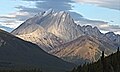 Mist Mountain seen from Highway 40

See also
References
- ^ "Mist Mountain". cdnrockiesdatabases.ca. Retrieved 2021-09-10.r
- ^ "Mist Mountain". Bivouac.com. Retrieved 2009-01-02.
- ^ "Mist Mountain". Geographical Names Data Base. Natural Resources Canada. Retrieved 2023-08-19.
- ^ Gadd, Ben (2008), Geology of the Rocky Mountains and Columbias
- ^ "Mist Mountain Natural Hot Springs Hike". explorekananaskis.com. Retrieved 2023-07-27.
- ^ Peel, M. C.; Finlayson, B. L. & McMahon, T. A. (2007). "Updated world map of the Köppen−Geiger climate classification". Hydrol. Earth Syst. Sci. 11: 1633–1644. ISSN 1027-5606.
External links
- "Mist Mountain". Peakware.com. Archived from the original on 2016-03-04.
- Mist Mountain weather: Mountain Forecast