Mount Manaia
Standing 420 metres, the summit offers outstanding views of the Marsden Point Oil Refinery, Bream Bay and the Hauraki Gulf to the south, Whangārei Harbour to the west and the Poor Knights Islands and Northland coast to the north.
Mt Manaia - along with Mt Lion, Bream Head and the Hen and Chicken Islands, are the scattered remnants of andesite, volcanic intusions that erupted with force 16 to 22 million years ago during the early Miocene. They are part of a 50 km (19 sq mi) stratovolcano that extended to the Hen and Chickens. Its jagged outline is similar to that of its neighbours and other volcanic outcrops in Northland that erupted in a similar period.
Today blanketed by native bush, Manaia's jagged peaks and steep bluffs are protected within a Department of Conservation reserve which features a well-maintained 1½ hour track to the summit.
Photo gallery
-
 Mt Manaia viewed from Manaia Baptist Camp at Taurikura
 -
 Manaia Ridge Scenic Reserve
 -
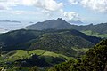
 Mt Lion and Taurikura viewed from the flanks of Mt Manaia
 -
 Whangārei Harbour viewed from the summit
 -
 Looking down at the Marsden Point Oil Refinery from across Whangārei Harbour
 -
 Bream Head and the Bream Islands viewed from atop the summit
 -
 The Bream Islands with Great Barrier Island in the distance viewed from Mt Manaia


References
- ^ Booden, Mathijs A.; Smith, Ian E.M.; Black, Philippa M.; Mauk, Jeffrey L. (2011). "Geochemistry of the Early Miocene volcanic succession of Northland, New Zealand, and implications for the evolution of subduction in the Southwest Pacific". Journal of Volcanology and Geothermal Research. 199 (1–2): 25–37. doi:10.1016/j.jvolgeores.2010.10.006. ISSN 0377-0273.
- ^ Hayward, Bruce; Smith, Ian (2002). "Field Trip 3-5: Introduction to Whangarei geology" (PDF). In Smith, Vicki; Grenfell, Hugh (eds.). Field Trip Guides, GSNZ Annual Conference "Northland 2002". Geological Society of NZ Miscellaneous Publication 112B. Archived from the original (PDF) on 22 June 2006. Retrieved 12 December 2022.
Sources
- Geological Society of New Zealand Annual Conference, 2-5 December 2002
- Te Ara Encyclopedia of New Zealand
- Northland Naturally, Mt Manaia web page
External links
This Northland Region-related geography article is a stub. You can help Wikipedia by expanding it. |