Mount Raymond (Utah)
Description
Mount Raymond is set along the boundary of the Mount Olympus Wilderness on land managed by Wasatch National Forest, with Salt Lake City 11 miles to the west and Park City 11 miles to the east. It is situated in the Wasatch Range which is a subset of the Rocky Mountains. Neighbors include Mount Olympus four miles to the west, Kesler Peak three miles southeast, and line parent Gobblers Knob is 1.5 mile to the northeast. Precipitation runoff from the mountain's north slope drains to Mill Creek, whereas the south slope drains to Big Cottonwood Creek. Topographic relief is significant as the summit rises 3,640 feet (1,110 meters) above Big Cottonwood Canyon in 1.5 mile. This mountain's toponym has been officially adopted by the United States Board on Geographic Names.
Climate
Mount Raymond has a subarctic climate (Köppen Dfc), bordering on an Alpine climate (Köppen ET), with long, cold, snowy winters, and cool to warm summers. Due to its altitude, it receives precipitation all year, as snow in winter, and as thunderstorms in summer.
Gallery
-
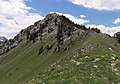 Approaching summit from northeast ridge
 -
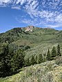 Mt. Raymond, east aspect
 -
 Mount Raymond (left) and Gobblers Knob (right) from southeast
 -
 East aspect from Big Cottonwood Canyon
 -
 Mount Raymond (left) and Gobblers Knob (right)
 -
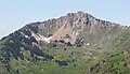 East aspect


.jpg)
See also
References
- ^ United States Geological Survey topographical map - Mount Aire
- ^ William T. Parry (2016), Geology of Utah's Mountains, Peaks, and Plateaus, FriesenPress, ISBN 9781460284131
- ^ "Mount Raymond, Utah". Peakbagger.com. Retrieved August 12, 2022.
- ^ "Raymond, Mount - 10,241' UT". listsofjohn.com. Retrieved August 12, 2022.
- ^ "Mount Raymond". Geographic Names Information System. United States Geological Survey, United States Department of the Interior. Retrieved August 12, 2022.
- ^ Peel, M. C.; Finlayson, B. L.; McMahon, T. A. (2007). "Updated world map of the Köppen−Geiger climate classification". Hydrol. Earth Syst. Sci. 11. ISSN 1027-5606.
External links
- Mount Raymond: weather forecast
- National Geodetic Survey Data Sheet