Mount Wintour
History
The mountain was named in honor of Captain Charles John Wintour (1871–1916), Royal Navy commander of the 4th Destroyer Flotilla. He was killed when his flagship, the destroyer HMS Tipperary was sunk by the German battleship SMS Westfalen during the Battle of Jutland in World War I. The mountain's toponym was officially adopted in 1928 by the Geographical Names Board of Canada.
The first ascent of the peak was made in August 1968 by Glen Boles and E. Peyer via the North Ridge.
Geology
Mount Wintour is composed of sedimentary rock laid down during the Precambrian to Jurassic periods. Formed in shallow seas, this sedimentary rock was pushed east and over the top of younger rock during the Laramide orogeny.
Climate
Based on the Köppen climate classification, Mount Wintour is located in a subarctic climate with cold, snowy winters, and mild summers. Temperatures can drop below −20 °C (−4 °F) with wind chill factors below −30 °C (−22 °F).
The months June through September offer the most favorable weather to climb Mount Wintour.
Precipitation runoff from the mountain drains into the Kananaskis River.
Gallery
-
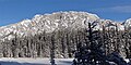 West aspect in winter
 -
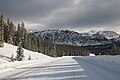 Mount Wintour in winter

.jpg)
See also
References
- ^ "Mount Wintour". Bivouac.com. Retrieved 2018-11-28.
- ^ "Mount Wintour". Geographical Names Data Base. Natural Resources Canada. Retrieved 2018-11-28.
- ^ "Opal Range". Peakbagger.com. Retrieved 2019-09-24.
- ^ Mount Wintour SummitPost
- ^ Place-names of Alberta. Ottawa: Geographic Board of Canada. 1928. p. 136.
- ^ Battle of Jutland Alberta Historic Places
- ^ Gadd, Ben (2008). Geology of the Rocky Mountains and Columbias.
- ^ Peel, M. C.; Finlayson, B. L.; McMahon, T. A. (2007). "Updated world map of the Köppen−Geiger climate classification". Hydrol. Earth Syst. Sci. 11: 1633–1644. ISSN 1027-5606.
External links
- Charles John Wintour Charles Wintour biography
- Mount Wintour weather: Mountain Forecast