Municipalities Of Tabasco
Municipalities in Tabasco are administratively autonomous of the state according to the 115th article of the 1917 Constitution of Mexico. Every three years, citizens elect a municipal president (Spanish: presidente municipal), by a plurality voting system, who heads a concurrently elected municipal council (ayuntamiento) which is responsible for providing all the public services for their constituents. The municipal council consists of a variable number of trustees and councillors (regidores y síndicos). Municipalities are responsible for public services (such as water and sewerage), street lighting, public safety, traffic, and the maintenance of public parks, gardens and cemeteries. They may also assist the state and federal governments in education, emergency fire and medical services, environmental protection and maintenance of monuments and historical landmarks. Since 1984, they have had the power to collect property taxes and user fees, although more funds are obtained from the state and federal governments than from their own income.
The largest municipality by population is Centro, with 683,607 residents while the smallest is Jonuta with 30,798 residents. The largest municipality by land area is Huimanguillo which spans 3,729.69 km (1,440.04 sq mi), and the smallest is Jalpa de Méndez with 370.83 km (143.18 sq mi). Tabasco has kept the same number of municipalities since 1883, one of the few Mexican states without recent changes.
Municipalities
- Largest municipalities in Tabasco by population
-
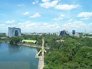 Centro, largest municipality by population in Tabasco
 -
 Cárdenas, second largest municipality by population
 -
 Comalcalco, third largest municipality by population


| Name | Municipal seat | Population (2020) |
Population (2010) |
Change | Land area | Population density (2020) |
Incorporation date | |
|---|---|---|---|---|---|---|---|---|
| km | sq mi | |||||||
| Balancán | Balancán | 58,524 | 56,739 | +3.1% | 3,588.92 | 1,385.69 | 16.3/km (42.2/sq mi) | April 26, 1837 |
| Cárdenas | Cárdenas | 243,229 | 248,481 | −2.1% | 2,055.61 | 793.67 | 118.3/km (306.5/sq mi) | December 18, 1883 |
| Centla | Frontera | 107,731 | 102,110 | +5.5% | 2,701.85 | 1,043.19 | 39.9/km (103.3/sq mi) | December 18, 1883 |
| Centro | Villahermosa† | 683,607 | 640,359 | +6.8% | 1,723.38 | 665.40 | 396.7/km (1,027.4/sq mi) | February 5, 1825 |
| Comalcalco | Comalcalco | 214,877 | 102,110 | +110.4% | 770.67 | 297.56 | 278.8/km (722.1/sq mi) | November 14, 1834 |
| Cunduacán | Cunduacán | 137,257 | 126,416 | +8.6% | 600.58 | 231.88 | 228.5/km (591.9/sq mi) | February 5, 1825 |
| Emiliano Zapata | Emiliano Zapata | 32,181 | 29,518 | +9.0% | 594.23 | 229.44 | 54.2/km (140.3/sq mi) | December 18, 1883 |
| Huimanguillo | Huimanguillo | 190,885 | 179,285 | +6.5% | 3,729.69 | 1,440.04 | 51.2/km (132.6/sq mi) | February 5, 1857 |
| Jalapa | Jalapa | 37,749 | 36,391 | +3.7% | 594.26 | 229.45 | 63.5/km (164.5/sq mi) | February 5, 1825 |
| Jalpa de Méndez | Jalpa de Méndez | 91,185 | 83,356 | +9.4% | 370.83 | 143.18 | 245.9/km (636.9/sq mi) | February 5, 1825 |
| Jonuta | Jonuta | 30,798 | 29,511 | +4.4% | 1,650.18 | 637.14 | 18.7/km (48.3/sq mi) | June 30, 1842 |
| Macuspana | Macuspana | 158,601 | 153,132 | +3.6% | 2,436.89 | 940.89 | 65.1/km (168.6/sq mi) | February 5, 1825 |
| Nacajuca | Nacajuca | 150,300 | 115,066 | +30.6% | 536.87 | 207.29 | 280.0/km (725.1/sq mi) | February 5, 1825 |
| Paraíso | Paraíso | 96,741 | 86,620 | +11.7% | 409.33 | 158.04 | 236.3/km (612.1/sq mi) | December 18, 1883 |
| Tacotalpa | Tacotalpa | 47,905 | 46,302 | +3.5% | 737.00 | 284.56 | 65.0/km (168.3/sq mi) | February 5, 1825 |
| Teapa | Teapa | 58,718 | 53,555 | +9.6% | 422.18 | 163.00 | 139.1/km (360.2/sq mi) | February 5, 1825 |
| Tenosique | Tenosique | 62,310 | 58,960 | +5.7% | 1,888.53 | 729.16 | 33.0/km (85.5/sq mi) | December 18, 1883 |
| Tabasco | — | 2,402,598 | 2,238,603 | +7.3% | 24,738 | 9,551.40 | 97.1/km (251.5/sq mi) | — |
| Mexico | — | 126,014,024 | 112,336,538 | +12.2% | 1,972,550 | 761,606 | 63.9/km (165.5/sq mi) | — |
Notes
- ^ Emiliano Zapata was originally incorporated as Montecristo, changing its name on December 27, 1927.
References
- ^ "Censo de Población y Vivienda 2020 - SCITEL" (in Spanish). INEGI. Retrieved January 27, 2021.
- ^ "Unidad de Microrregiones Cédulas de Información Municipal (SCIM) - Tabasco" (in Spanish). Secretaría de Desarrollo Social. Retrieved February 10, 2020.
- ^ Constitución Política de los Estados Unidos Mexicanos (Article 115) (in Spanish). 1917. Retrieved September 27, 2017.
- ^ OECD (November 12, 2004). New Forms of Governance for Economic Development. OECD Publishing. p. 121. ISBN 9264015329.
- ^ Mexico Company Laws and Regulations Handbook. International Business Publications. 2009. p. 42. ISBN 9781433070303.
- ^ Estado de Tabasco División Territorial de 1810 a 1995 (PDF) (in Spanish). Mexico: INEGI. 1996. ISBN 970-13-1514-6.
- ^ "Localidades y su población por municipio segun tamaño de localidad" (PDF) (in Spanish). INEGI. Archived from the original (PDF) on August 31, 2018. Retrieved March 11, 2018.

| |
Mexico City is a sui generis political entity and is administratively divided into boroughs. |