Ormondville
Ormondville railway station opened in 1880, but services ended in 2001.
- Ormondville buildings
-
 Masonic Lodge
 -
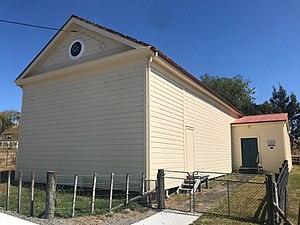
 Anglican Church of Epiphany


History
Ormondville was in the 8,230 acres (3,330 ha) Tuatua Block, which was part of the 183,430 acres (74,230 ha) Seventy Mile Bush area, bought by government for £17,552 on 16 August 1871, from Hohepa Paewai, a chief of the Rangitāne iwi. The area was then sold to settlers by the Waste Lands Board, through a Special Settlement Scheme. Ormondville was named after John Davies Ormond, who was then the local MP and Superintendent of Hawke's Bay Province. Ormondville used to be much larger; in 1901 the population was 459. It once had a court-house (1881-1932), Alpha dairy factory (1899-1931), hotel, cobbler, garage, butchery, blacksmith, saddler, undertaker, solicitor, library, draper, billiard room, 3 stores, police station, school, an Anglican and a Catholic church, library, hall, bakery, sports ground and railway station. It had a Town Board (including the Makotuku Riding) from 1885 until 1944, when it merged into Dannevirke County Council, following a petition. A hydro electric plant was installed at nearby Cave Farm in 1906, but power wasn't connected to Ormondville until the late 1920s.
Ormondville railway station

Ormondville railway station, on the Palmerston North–Gisborne line, opened on 9 August 1880, closed to goods on 31 August 1985 and the last regular passenger train was the Bay Express on 7 October 2001. The station, goods shed and sidings remain and it has been protected by a Category 2 listing since 7 April 1983. Since 1986 it has been maintained by Ormondville Rail Preservation Group and offers beds for tourists.
In 1878 about 100 navvies were working on the 5 mi 22 ch (8.5 km) Makotuku extension of the line from Napier and Spit to Kopua. The work had been let out in small contracts to settlers from Danevirke, Makaretu, Norsewood and Ormondville. It included 3 large viaducts (Kopua, Ormondville and Makotuku) over the Manawatū River and its tributaries. Work was delayed by subsidence near Kopua; it had been planned to complete the extension by 29 July 1879. There was no formal opening of this section, which was delayed by a couple of days by a slip.
Originally it wasn't clear which of the settlements in the Seventy Mile bush would develop enough to justify a station. In 1878 there was still doubt that Ormondville would have one. A station and water supply were planned in 1879. Initially Ormondville wasn't always shown in timetables, but from 27 June 1881 it became a flag station, with 2 trains a day each way. From April 1882 it was no longer shown as a flag station. It was shown in 1891 still with 2 trains a day. By 1897 it had 3 trains a day. In 1910 it took over 7 hours from Wellington, but by the 1940s the journey was 4 to 5 hours. By 1981 the Endeavour took about 3½ hours, as did the Bay Express.
Initially the station would have been very spartan, as it wasn't until August 1880 that authority was sought for furnishing it and in 1882 there was negotiation over whether Public Works or NZR would pay for a ladies waiting room. There was a post office at the station from 1883 to 1914 and in 1891, when the platform length was doubled, consideration was given to providing refreshment rooms. By 1896 there was a 5th class station (12 ft 9 in (3.89 m) x 32 ft 6 in (9.91 m)), with office and ladies rooms, waiting lobby, platform, cart access, stationmaster's house, a 30 ft (9.1 m) x 20 ft (6.1 m) goods shed (extended to 60 ft (18 m) by 1906), urinals and a passing loop for 14 wagons. In 1898 the loop was for 20 wagons and it was further lengthened in 1925 for 59 wagons. Cattle yards were added in 1898, lit in 1913 and extended in 1908 and 1920. A verandah was added in 1901. Railway houses were added in 1919, 1927 and 1938. By 1926 the platform was 210 ft (64 m) long, with 15 ft (4.6 m) ramps and extended 50 ft (15 m) in 1927. In 1959 a verandah was added to the goods shed to protect dairy goods and the loading bank was extended in 1965.
In the 1880s and 90s there were sawmills with tramways to their mills and the railway. In 1881 Alfred Levy & W W Gundrie applied for a tramway across the road at Ormondville station. Samuel Baines Firth took over one of Gundrie's mills and had a tramway from 1882 to 1884. G Grant applied for a tramway in 1886 and had one hauling timber from before 1889 to 1891.
Ormondville was among the lower traffic stations on the line. For example, in 1923 it sold 8,138 tickets, though it was among the larger stations in its export of 111,168 sheep and pigs. In 1933 there was a bus link to Te Uri, towards the coast.

Ormondville viaduct

Ormondville Viaduct (bridge 156) is 281 m (922 ft) long and 39 m (128 ft) above the Mangarangiora Stream. The original timber (probably totara) truss viaduct was built between 1878 and 1880 by Proudfoot and Angus Mackay (who built the bridge at Clive and who, in 1892, was the first Mayor of Dannevirke). It was 618 ft (188 m) long, 96 ft (29 m) above the stream and used 404,000 ft (123,000 m) of timber, and 20 tons of iron, in 21 x 30 ft (9.1 m) spans, 1 x 11 ft (3.4 m) and 1 x 6 ft (1.8 m). The contract for this and two neighbouring bridges was for £16,758, or £15,195 1s 8d.
J & A Anderson & Co of Christchurch won a tender for a wrought iron replacement on 16 November 1904 and completed the work with a ceremonial driving of the last rivet on 20 October 1906. In the same era Andersons also rebuilt Kopua (1895), Makotuku (1898), Matamau (1899), Mangatera (1900) and Makatote (1908) viaducts. There are 6 large viaducts on the 24.57 km (15.27 mi) between Kopua and Dannevirke, including Makotuku Viaduct, between Ormondville and Makotuku, which is 128 m (420 ft) long and 26 m (85 ft) high, over Makotuku Stream, a tributary of the Manawatū River. There was a minor fire on the viaduct on 1 February 1931.
Chimneys in Ormondville fell in the 1904 earthquake and after the 1931 quakes the viaduct was closed for repairs for a week in 1932. and then a washout occurred about a month later, after a new approach had been built. The bank approaching the viaduct also subsided slightly in a 1934 quake and again in 1961. One of the piers cracked by the 1931 quake was replaced in 1941. The Bay Express was stopped on the viaduct during the Weber earthquake in 1990 and a freight train during the 2014 Eketahuna earthquake. In 1990 the track at the northern end of the viaduct was left unsupported. Strengthening of the viaduct was in a 3-year plan announced in 2021.
Demographics
Ormondville is described by Statistics New Zealand as a rural settlement and covers 0.29 km (0.11 sq mi). It had an estimated population of 70 as of June 2024, with a population density of 241 people per km. It is part of the larger Norsewood statistical area.
| Year | Pop. | ±% p.a. |
|---|---|---|
| 2006 | 75 | — |
| 2013 | 63 | −2.46% |
| 2018 | 69 | +1.84% |
| Source: | ||
Ormondville had a population of 69 at the 2018 New Zealand census, an increase of 6 people (9.5%) since the 2013 census, and a decrease of 6 people (−8.0%) since the 2006 census. There were 36 households, comprising 33 males and 36 females, giving a sex ratio of 0.92 males per female. The median age was 49.5 years (compared with 37.4 years nationally), with 12 people (17.4%) aged under 15 years, 3 (4.3%) aged 15 to 29, 42 (60.9%) aged 30 to 64, and 9 (13.0%) aged 65 or older.
Ethnicities were 91.3% European/Pākehā, and 17.4% Māori. People may identify with more than one ethnicity.
Although some people chose not to answer the census's question about religious affiliation, 56.5% had no religion, 26.1% were Christian, and 4.3% had Māori religious beliefs.
Of those at least 15 years old, 21 (36.8%) people had no formal qualifications. The median income was $24,700, compared with $31,800 nationally. 3 people (5.3%) earned over $70,000 compared to 17.2% nationally. The employment status of those at least 15 was that 18 (31.6%) people were employed full-time, 6 (10.5%) were part-time, and 3 (5.3%) were unemployed.
Education
Ormondville School opened in 1878 and merged into Norsewood School in 2003.
Climate
| Climate data for Kopua (1991–2020) | |||||||||||||
|---|---|---|---|---|---|---|---|---|---|---|---|---|---|
| Month | Jan | Feb | Mar | Apr | May | Jun | Jul | Aug | Sep | Oct | Nov | Dec | Year |
| Mean daily maximum °C (°F) | 22.6 (72.7) |
22.5 (72.5) |
20.6 (69.1) |
17.6 (63.7) |
15.0 (59.0) |
12.4 (54.3) |
11.6 (52.9) |
12.5 (54.5) |
14.5 (58.1) |
16.6 (61.9) |
18.1 (64.6) |
20.7 (69.3) |
17.1 (62.7) |
| Daily mean °C (°F) | 17.2 (63.0) |
17.3 (63.1) |
15.4 (59.7) |
12.9 (55.2) |
10.6 (51.1) |
8.3 (46.9) |
7.7 (45.9) |
8.4 (47.1) |
10.1 (50.2) |
11.9 (53.4) |
13.3 (55.9) |
15.7 (60.3) |
12.4 (54.3) |
| Mean daily minimum °C (°F) | 11.8 (53.2) |
12.1 (53.8) |
10.3 (50.5) |
8.1 (46.6) |
6.3 (43.3) |
4.3 (39.7) |
3.8 (38.8) |
4.2 (39.6) |
5.6 (42.1) |
7.3 (45.1) |
8.5 (47.3) |
10.8 (51.4) |
7.8 (46.0) |
| Average rainfall mm (inches) | 74.7 (2.94) |
76.3 (3.00) |
74.4 (2.93) |
73.2 (2.88) |
81.1 (3.19) |
97.8 (3.85) |
116.2 (4.57) |
87.0 (3.43) |
85.5 (3.37) |
90.1 (3.55) |
72.1 (2.84) |
76.1 (3.00) |
1,004.5 (39.55) |
| Source: NIWA (rain 1981–2010) | |||||||||||||
References
Citations
- ^ "ArcGIS Web Application". statsnz.maps.arcgis.com. Retrieved 12 May 2023.
- ^ "Aotearoa Data Explorer". Statistics New Zealand. Retrieved 26 October 2024.
- ^ Forrester, Georgia (13 November 2017). "Welcome to town: Ormondville, a sleepy little railway town". Manawatū Standard.
- ^ Pollock, Kerryn (30 November 2015). "Ormondville railway station". Te Ara: The Encyclopedia of New Zealand.
- ^ "Statement showing area of lands purchased and leased (transactions complete and incomplete), with expenditure thereon, under the Immigration and Public Works Acts of 1870 and 1873". paperspast.natlib.govt.nz. 1874. Retrieved 18 September 2021.
- ^ "Rangitāne historian recalls 'visionary' Tararua chief on Waitangi Day". Stuff. 5 February 2020. Retrieved 18 September 2021.
- ^ "HAWKE'S BAY HERALD". paperspast.natlib.govt.nz. 10 July 1878. Retrieved 18 September 2021.
- ^ Taonga, New Zealand Ministry for Culture and Heritage Te Manatu. "Ormond, John Davies". teara.govt.nz. Retrieved 18 September 2021.
- ^ "RESULTS OF A CENSUS OF THE COLONY OF NEW ZEALAND". 31 March 1901.
- ^ "WAIPAWA. DAILY TELEGRAPH". paperspast.natlib.govt.nz. 20 December 1881. Retrieved 9 September 2021.
- ^ "LOCAL AND GENERAL. FEILDING STAR". paperspast.natlib.govt.nz. 8 February 1932. Retrieved 18 September 2021.
- ^ "Ormondville". nzetc.victoria.ac.nz. Retrieved 18 September 2021.
- ^ "Ormondville Dairy Factory Has Been Demolished. MANAWATU TIMES". paperspast.natlib.govt.nz. 5 June 1937. Retrieved 18 September 2021.
- ^ "FIRE AT ORMONDVILLE. MANAWATU STANDARD". paperspast.natlib.govt.nz. 9 February 1939. Retrieved 18 September 2021.
- ^ "Disastrous Fire at Ormondville. MANAWATU TIMES". paperspast.natlib.govt.nz. 24 March 1931. Retrieved 18 September 2021.
- ^ "PLEADS GUILTY TO CHARGE OF ARSON. MANAWATU TIMES". paperspast.natlib.govt.nz. 27 April 1927. Retrieved 18 September 2021.
- ^ "101 years of Ormondville May 1878". sites.rootsweb.com. 1978. Retrieved 18 September 2021.
- ^ "Ormondville". nzetc.victoria.ac.nz. Retrieved 18 September 2021.
- ^ "Taranaki and Hawke's Bay Cyclopedia of New Zealand" (PDF). 1906.
- ^ "Ormondville Town Board". archivescentral.org.nz. Retrieved 18 September 2021.
- ^ "New Zealand Gazette" (PDF). 22 June 1944.
- ^ "PIGEON SLAUGHTER. BUSH ADVOCATE". paperspast.natlib.govt.nz. 12 December 1906. Retrieved 18 September 2021.
- ^ "AtoJs Online — Appendix to the Journals of the House of Representatives — 1927 Session I — D-01 PUBLIC WORKS STATEMENT (BY THE HON. K. S. WILLIAMS, MINISTER OF PUBLIC WORKS)". atojs.natlib.govt.nz. 1927. Retrieved 10 March 2021.
- ^ "Dannevirke. MANAWATU TIMES". paperspast.natlib.govt.nz. 30 April 1931. Retrieved 18 September 2021.
- ^ Names & Opening & Closing Dates of Railway Stations in New Zealand by Juliet Scoble (2012)
- ^ "KiwiRail Network Map". kiwirail.maps.arcgis.com. November 2018. Retrieved 21 September 2021.
- ^ "Ormondville Railway Station". www.heritage.org.nz. Retrieved 17 September 2021.
- ^ "Ormondville Rail Preservation Group". Ormondville Rail Preservation Group. Retrieved 17 September 2021.
- ^ "WAIPAWA MAIL". paperspast.natlib.govt.nz. 25 December 1878. Retrieved 13 September 2021.
- ^ "LINES DEALT WITH BY RAILWAY COMMISSION, 1880". paperspast.natlib.govt.nz. 1888. Retrieved 21 September 2021.
- ^ "PUBLIC WORKS STATEMENT, BY THE MINISTER FOR PUBLIC WORKS, THE HON. JAMES MACANDREW, THURSDAY, 7TH AUGUST, 1879". paperspast.natlib.govt.nz. Retrieved 16 September 2021.
- ^ "Station Archive". NZR Rolling Stock Lists. Retrieved 10 August 2020.
- ^ "KOPUA. WAIPAWA MAIL". paperspast.natlib.govt.nz. 15 February 1879. Retrieved 16 September 2021.
- ^ "OPENING OF THE MAKATOKU RAILWAY. WAIPAWA MAIL". paperspast.natlib.govt.nz. 11 August 1880. Retrieved 10 September 2021.
- ^ "FROM THE EAST COAST TO THE WEST. HAWKE'S BAY HERALD". paperspast.natlib.govt.nz. 10 January 1878. Retrieved 10 September 2021.
- ^ "HAWKE'S BAY HERALD". paperspast.natlib.govt.nz. 1 October 1880. Retrieved 19 September 2021.
- ^ "HAWKE'S BAY HERALD". paperspast.natlib.govt.nz. 26 April 1881. Retrieved 19 September 2021.
- ^ "DAILY TELEGRAPH". paperspast.natlib.govt.nz. 11 June 1881. Retrieved 19 September 2021.
- ^ "RAILWAY TIME-TABLE. WAIPAWA MAIL". paperspast.natlib.govt.nz. 29 April 1882. Retrieved 19 September 2021.
- ^ "WAIPAWA MAIL". paperspast.natlib.govt.nz. 3 March 1891. Retrieved 17 September 2021.
- ^ "HASTINGS STANDARD". paperspast.natlib.govt.nz. 10 May 1897. Retrieved 17 September 2021.
- ^ "RAILWAY TIME-TABLES. DOMINION". paperspast.natlib.govt.nz. 28 March 1910. Retrieved 26 September 2021.
- ^ "MANAWATU STANDARD". paperspast.natlib.govt.nz. 15 December 1945. Retrieved 19 September 2021.
- ^ "MANAWATU STANDARD". paperspast.natlib.govt.nz. 3 January 1944. Retrieved 19 September 2021.
- ^ "Ormondville Rail Preservation Group Inc. - Russell Murphy sent in this image - NZR's timetable for January 1981 - i.e 40 years ago this month. No longer any 'Endeavour' to pass through Ormondville at 11:26am or 3:59pm six days a week. Perhaps a Silver Fern though some day......? :-) | Facebook". www.facebook.com. Retrieved 26 September 2021.
- ^ Fares & Timetables. New Zealand Rail Ltd. 23 April 1995.
- ^ "THE POUND QUESTION. WOODVILLE EXAMINER". paperspast.natlib.govt.nz. 10 October 1891. Retrieved 27 September 2021.
- ^ Wheeler, Thomas S (1994). "All Aboard the Train" (PDF).
- ^ "BUSH ADVOCATE". paperspast.natlib.govt.nz. 8 December 1908. Retrieved 27 September 2021.
- ^ "OVER THE RANGE. MANAWATU TIMES". paperspast.natlib.govt.nz. 2 November 1920. Retrieved 27 September 2021.
- ^ "DISTRICT & GENERAL. BUSH ADVOCATE". paperspast.natlib.govt.nz. 30 July 1901. Retrieved 27 September 2021.
- ^ "HAWKE'S BAY HERALD". paperspast.natlib.govt.nz. 23 September 1879. Retrieved 27 September 2021.
- ^ "SUPREME COURT—CIVIL SITTINGS. HAWKE'S BAY HERALD". paperspast.natlib.govt.nz. 15 June 1885. Retrieved 27 September 2021.
- ^ "ORMONDVILLE. WAIPAWA MAIL". paperspast.natlib.govt.nz. 23 April 1889. Retrieved 27 September 2021.
- ^ "NEWS OF THE DAY. BUSH ADVOCATE". paperspast.natlib.govt.nz. 19 September 1889. Retrieved 27 September 2021.
- ^ "RETURN No. 12. Statement of Revenue for each Station for the Year ended 31st March, 1923". paperspast.natlib.govt.nz. Retrieved 18 September 2021.
- ^ "TRANSPORT LICENSING. MANAWATU STANDARD". paperspast.natlib.govt.nz. 15 December 1933. Retrieved 19 September 2021.
- ^ Yonge, John Roger; Company, Quail Map (1993). New Zealand Railway and Tramway Atlas. Quail Map Company. ISBN 9780900609923.
{{cite book}}:|last2=has generic name (help) - ^ "Bridge Number 158 Line Name Palmerston North - Gisborne Line". kiwirail.maps.arcgis.com. November 2018. Retrieved 6 September 2021.
- ^ New Zealand Railway and Tramway Atlas (First ed.). Quail Map Co. 1965. pp. 3 & 4.
- ^ "THE CLIMATE OF HAWKE'S BAY. WAIPAWA MAIL". paperspast.natlib.govt.nz. 14 December 1878. Retrieved 27 September 2021.
- ^ "OTAGO DAILY TIMES". paperspast.natlib.govt.nz. 29 January 1878. Retrieved 16 September 2021.
- ^ "Ex-Mayors". nzetc.victoria.ac.nz. Retrieved 9 October 2021.
- ^ "THE MAYORAL ELECTION. BUSH ADVOCATE". paperspast.natlib.govt.nz. 13 December 1892. Retrieved 9 October 2021.
- ^ "PERSONAL. MANAWATU STANDARD". paperspast.natlib.govt.nz. 29 December 1909. Retrieved 9 October 2021.
- ^ "RAILWAY BRIDGES IN THE NORTH ISLAND. OTAGO DAILY TIMES". paperspast.natlib.govt.nz. 3 April 1880. Retrieved 17 September 2021.
- ^ "PUBLIC WORKS STATEMENT, BY THE MINISTER FOR PUBLIC WORKS, THE HON. JAMES MACANDREW, TUESDAY, 27TH AUGUST, 1878". paperspast.natlib.govt.nz. Retrieved 17 September 2021.
- ^ "Heritage Assessment. Mangaweka Bridge, Mangaweka" (PDF). May 2015.
- ^ "Mangaweka Bridge" (PDF). Rangitikei District Council. May 2015.
- ^ New Zealand Railway and Tramway Atlas (First ed.). Quail Map Co. 1965. pp. 3 & 4.
- ^ "Makotuku Stream, Manawatu-Wanganui". NZ Topo Map. Retrieved 17 August 2021.
- ^ "Ormondville. MANAWATU TIMES". paperspast.natlib.govt.nz. 3 February 1931. Retrieved 17 September 2021.
- ^ "Violent Earthquake. WOODVILLE EXAMINER". paperspast.natlib.govt.nz. 10 August 1904. Retrieved 5 September 2021.
- ^ "LOCAL AND GENERAL. HOROWHENUA CHRONICLE". paperspast.natlib.govt.nz. 12 September 1932. Retrieved 19 September 2021.
- ^ "MANAWATU STANDARD". paperspast.natlib.govt.nz. 19 September 1932. Retrieved 19 September 2021.
- ^ "RAILWAY INTERRUPTION. MANAWATU STANDARD". paperspast.natlib.govt.nz. 6 March 1934. Retrieved 19 September 2021.
- ^ "MAIN TRUNK RAILWAY. PRESS". paperspast.natlib.govt.nz. 14 August 1961. Retrieved 27 September 2021.
- ^ "Viaduct Reconstruction. GISBORNE HERALD". paperspast.natlib.govt.nz. 16 May 1941. Retrieved 27 September 2021.
- ^ "Analysis of the Weber (Dannevirke) earthquakes of 2 February and 13 May 1990" (PDF). GNS. August 1992.
- ^ "Terror on the train". teara.govt.nz. Retrieved 17 September 2021.
- ^ "Ormondville Rail Preservation Group Inc. - The goods train that was stuck on the Ormondville Viaduct yesterday from the time of the earthquake around 4:00pm, until about 8:00pm". www.facebook.com. Retrieved 17 September 2021.
- ^ Dannevirke, NZ : Then and Now - "Mothers day" 1990 Dannevirke Earthquake Clip 02 | Facebook, retrieved 17 September 2021
- ^ "Inaugural rail programme creates certainty and jobs". KiwiRail. 8 July 2021. Retrieved 19 September 2021.
- ^ 2018 Census place summary: Norsewood
- ^ "Statistical area 1 dataset for 2018 Census". Statistics New Zealand. March 2020. 7018805.
- ^ "Hawke's Bay Education Board". Hawke's Bay Herald. 4 June 1878. p. 2.
- ^ "Merger of Awariki School (2545), Norsewood School (2622), Ormondville School (2632) and Matamau School (2610)". New Zealand Gazette. 28 August 2003.
- ^ "CliFlo – National Climate Database : Kopua". NIWA. Retrieved 20 May 2024.
Biblipgraphy
- Leitch, David; Scott, Brian (1995). Exploring New Zealand's Ghost Railways (1998 ed.). Wellington: Grantham House. ISBN 1-86934-048-5.
External links
Photos -