Pagan, Myanmar
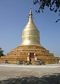
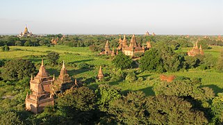
The Bagan Archaeological Zone is a main attraction for the country's nascent tourism industry.
Etymology
Bagan is the present-day standard Burmese pronunciation of the Burmese word Pugan (ပုဂံ), derived from Old Burmese Pukam (ပုကမ်). Its classical Pali name is Arimaddanapura (အရိမဒ္ဒနာပူရ, lit. "the City that Tramples on Enemies"). Its other names in Pali are in reference to its extreme dry zone climate: Tattadesa (တတ္တဒေသ, "parched land"), and Tampadīpa (တမ္ပဒီပ, "bronzed country"). The Burmese chronicles also report other classical names of Thiri Pyissaya (သီရိပစ္စယာ; Pali: Siripaccaya) and Tampawaddy (တမ္ပဝတီ; Pali: Tampavatī).
History
9th to 13th centuries


According to the royal chronicles, Bagan was founded in the second century CE, and fortified in 849 by King Pyinbya, 34th successor of the founder of early Bagan. Western scholarship however holds that Bagan was founded in the mid-to-late 9th century by the Mranma (Burmans), who had recently entered the Irrawaddy valley from the Nanzhao Kingdom. It was among several competing Pyu city-states until the late 10th century when the Burman settlement grew in authority and grandeur.
From 1044 to 1287, Bagan was the capital as well as the political, economic and cultural nerve center of the Bagan Empire. Over the course of 250 years, Bagan's rulers and their wealthy subjects constructed over 10,000 religious monuments (approximately 1000 stupas, 10,000 small temples and 3000 monasteries) in an area of 104 km (40 sq mi) in the Bagan plains. The prosperous city grew in size and grandeur, and became a cosmopolitan center for religious and secular studies, specializing in Pali scholarship in grammar and philosophical-psychological (abhidhamma) studies as well as works in a variety of languages on prosody, phonology, grammar, astrology, alchemy, medicine, and legal studies. The city attracted monks and students from as far as India, Sri Lanka and the Khmer Empire.
The culture of Bagan was dominated by religion. The religion of Bagan was fluid, syncretic and by later standards, unorthodox. It was largely a continuation of religious trends in the Pyu era where Theravada Buddhism co-existed with Mahayana Buddhism, Tantric Buddhism, various Hindu (Saivite, and Vaishana) schools as well as native animist (nat) traditions. While the royal patronage of Theravada Buddhism since the mid-11th century had enabled the Buddhist school to gradually gain primacy, other traditions continued to thrive throughout the Pagan period to degrees later unseen.
Bagan's basic physical layout had already taken shape by the late 11th century, which was the first major period of monument building. A main strip extending for about 9 km along the east bank of the Irrawaddy emerged during this period, with the walled core (known as "Old Bagan") in the middle. 11th-century construction took place throughout this whole area and appears to have been relatively decentralized. The spread of monuments north and south of Old Bagan, according to Hudson, Nyein Lwin, and Win Maung, may reflect construction at the village level, which may have been encouraged by the main elite at Old Bagan.
The peak of monument building took place between about 1150 and 1200. Most of Bagan's largest buildings were built during this period. The overall amount of building material used also peaked during this phase. Construction clustered around Old Bagan, but also took place up and down the main strip, and there was also some expansion to the east, away from the Irrawaddy.
By the 13th century, the area around Old Bagan was already densely packed with monuments, and new major clusters began to emerge to the east. These new clusters, like the monastic area of Minnanthu, were roughly equally distant – and equally accessible – from any part of the original strip that had been defined in the 11th century. Construction during the 13th century featured a significant increase in the building of monasteries and associated smaller monuments. Michael Aung-Thwin has suggested that the smaller sizes may indicate "dwindling economic resources" and that the clustering around monasteries may reflect growing monastic influence. Bob Hudson, Nyein Lwin, and Win Maung also suggest that there was a broadening of donor activity during this period: "the religious merit that accrued from endowing an individual merit was more widely accessible", and more private individuals were endowing small monuments. As with before, this may have taken place at the village level.
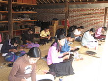
Both Bagan itself and the surrounding countryside offered plenty of opportunities for employment in various sectors. The prolific temple building alone would have been a huge stimulus for professions involved in their construction, such as brickmaking and masonry; gold, silver, and bronze working; carpentry and woodcarving; and ceramics. Finished temples would still need maintenance work done, so they continued to boost demand for both artisans' services and unskilled labor well after their construction. Accountants, bankers, and scribes were also necessary to manage the temple properties. These workers, especially the artisans, were paid well, which attracted many people to move to Bagan. Contemporary inscriptions indicate that "people of many linguistic and cultural backgrounds lived and worked" in Bagan during this time period.
Bagan's ascendancy also coincided with a period of political and economic decline in several other nearby regions, like Dvaravati, Srivijaya, and the Chola Empire. As a result, immigrants from those places likely also ended up moving to Bagan, in addition to people moving there from within Myanmar.
The Pagan Empire collapsed in 1287 due to repeated Mongol invasions (1277–1301). Recent research shows that Mongol armies may not have reached Bagan itself, and that even if they did, the damage they inflicted was probably minimal. According to Michael Aung-Thwin, a more likely explanation is that the provincial governors tasked with defending against Mongol incursions were so successful that they became "the new power elite", and their capitals became the new political centers while Bagan itself became a backwater. In any case, something during this period caused Bagan to decline. The city, once home to some 50,000 to 200,000 people, had been reduced to a small town, never to regain its preeminence. The city formally ceased to be the capital of Burma in December 1297 when the Myinsaing Kingdom became the new power in Upper Burma.
14th to 19th centuries

Bagan survived into the 15th century as a human settlement, and as a pilgrimage destination throughout the imperial period. A smaller number of "new and impressive" religious monuments still went up to the mid-15th century but afterward, new temple constructions slowed to a trickle with fewer than 200 temples built between the 15th and 20th centuries. The old capital remained a pilgrimage destination but pilgrimage was focused only on "a score or so" most prominent temples out of the thousands such as the Ananda, the Shwezigon, the Sulamani, the Htilominlo, the Dhammayazika, and a few other temples along an ancient road. The rest—thousands of less famous, out-of-the-way temples—fell into disrepair, and most did not survive the test of time.
For the few dozen temples that were regularly patronized, the continued patronage meant regular upkeep as well as architectural additions donated by the devotees. Many temples were repainted with new frescoes on top of their original Pagan era ones, or fitted with new Buddha statutes. Then came a series of state-sponsored "systematic" renovations in the Konbaung period (1752–1885), which by and large were not true to the original designs—some finished with "a rude plastered surface, scratched without taste, art or result". The interiors of some temples were also whitewashed, such as the Thatbyinnyu and the Ananda. Many painted inscriptions and even murals were added in this period.
20th century to present
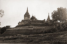
Bagan, located in an active earthquake zone, had suffered from many earthquakes over the ages, with over 400 recorded earthquakes between 1904 and 1975. A major earthquake occurred on 8 July 1975, reaching 8 MM in Bagan and Myinkaba, and 7 MM in Nyaung-U. The quake damaged many temples, in many cases, such as the Bupaya, severely and irreparably. Today, 2229 temples and pagodas remain.
Many of these damaged pagodas underwent restorations in the 1990s by the military government, which sought to make Bagan an international tourist destination. However, the restoration efforts instead drew widespread condemnation from art historians and preservationists worldwide. Critics were aghast that the restorations paid little attention to original architectural styles, and used modern materials, and that the government has also established a golf course, a paved highway, and built a 61 m (200 ft) watchtower. Although the government believed that the ancient capital's hundreds of (unrestored) temples and large corpus of stone inscriptions were more than sufficient to win the designation of UNESCO World Heritage Site, the city was not so designated until 2019, allegedly mainly on account of the restorations.
On 24 August 2016, a major earthquake hit Bagan, and caused major damages in nearly 400 temples. The Sulamani and Myauk Guni temples were severely damaged. The Bagan Archaeological Department began a survey and reconstruction effort with the help of the UNESCO. Visitors were prohibited from entering 33 much-damaged temples.
On 6 July 2019, Bagan was officially inscribed as a World Heritage Site by the UNESCO, 24 years after its first nomination, during the 43rd session of the World Heritage Committee. Bagan became the second World Heritage Site in Myanmar, after the Ancient Cities of Pyu. As part of the criteria for the inscription of Bagan, the government had pledged to relocate existing hotels in the archaeological zone to a dedicated hotel zone by 2020.
Bagan today is a main tourist destination in the country's nascent tourism industry.
Geography
The Bagan Archaeological Zone, defined as the 13 km × 8 km (8.1 mi × 5.0 mi) area centred around Old Bagan, consisting of Nyaung U in the north and New Bagan in the south, lies in the vast expanse of plains in Upper Burma on the bend of the Irrawaddy river. It is located 290 km (180 mi) south-west of Mandalay and 700 km (430 mi) north of Yangon.
Climate
Bagan lies in the middle of the Dry Zone, the region roughly between Shwebo in the north and Pyay in the south. Unlike the coastal regions of the country, which receive annual monsoon rainfalls exceeding 2,500 mm (98 in), the dry zone gets little precipitation as it is sheltered from the rain by the Rakhine Yoma mountain range in the west.
Available online climate sources report Bagan climate quite differently.
| Climate data for Bagan | |||||||||||||
|---|---|---|---|---|---|---|---|---|---|---|---|---|---|
| Month | Jan | Feb | Mar | Apr | May | Jun | Jul | Aug | Sep | Oct | Nov | Dec | Year |
| Mean daily maximum °C (°F) | 32 (90) |
35 (95) |
36 (97) |
37 (99) |
33 (91) |
30 (86) |
30 (86) |
30 (86) |
30 (86) |
32 (90) |
32 (90) |
32 (90) |
32 (91) |
| Mean daily minimum °C (°F) | 18 (64) |
19 (66) |
22 (72) |
24 (75) |
25 (77) |
25 (77) |
24 (75) |
24 (75) |
24 (75) |
24 (75) |
22 (72) |
19 (66) |
23 (72) |
| Source: www.holidaycheck.com | |||||||||||||
| Climate data for Bagan | |||||||||||||
|---|---|---|---|---|---|---|---|---|---|---|---|---|---|
| Month | Jan | Feb | Mar | Apr | May | Jun | Jul | Aug | Sep | Oct | Nov | Dec | Year |
| Mean daily maximum °C (°F) | 28 (82) |
32 (90) |
36 (97) |
39 (102) |
38 (100) |
35 (95) |
33 (91) |
32 (90) |
32 (90) |
31 (88) |
29 (84) |
27 (81) |
33 (91) |
| Mean daily minimum °C (°F) | 16 (61) |
19 (66) |
24 (75) |
28 (82) |
29 (84) |
27 (81) |
26 (79) |
25 (77) |
25 (77) |
24 (75) |
20 (68) |
17 (63) |
23 (74) |
| Average rainfall mm (inches) | 5 (0.2) |
0.6 (0.02) |
2.6 (0.10) |
16.4 (0.65) |
49.6 (1.95) |
69.8 (2.75) |
126.7 (4.99) |
182 (7.2) |
152.4 (6.00) |
103.6 (4.08) |
25.5 (1.00) |
5.7 (0.22) |
739.9 (29.16) |
| Average rainy days | 2 | 1 | 2 | 9 | 14 | 21 | 26 | 28 | 24 | 20 | 6 | 2 | 155 |
| Source: www.weatheronline.com | |||||||||||||


