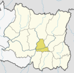
Pakhribas Municipality
When the Government of Nepal decided to reduce the local level body in 753 units, all previous VDCs nullified and merged with existing municipalities (some instead created new municipalities), so Chungmang VDC merged with Pakhribas on 10 March 2017.
The total area of the municipality is 144.29 square kilometres (55.71 sq mi) and the total population of the municipality is 22,078 as of the 2011 Nepal census. The municipality is divided into a total of 10 wards.
History
Pakhribas was a village development committee in Dhankuta District in the Kosi Zone of the Eastern Development Region before 2014. At the time of the 1991 Nepal census, it had a population of 4508 people living in 890 individual households.
Climate
| Climate data for Pakhribas, elevation 1,680 m (5,510 ft), (1976–2005) | |||||||||||||
|---|---|---|---|---|---|---|---|---|---|---|---|---|---|
| Month | Jan | Feb | Mar | Apr | May | Jun | Jul | Aug | Sep | Oct | Nov | Dec | Year |
| Mean daily maximum °C (°F) | 14.4 (57.9) |
16.3 (61.3) |
20.5 (68.9) |
23.8 (74.8) |
24.1 (75.4) |
24.0 (75.2) |
23.3 (73.9) |
23.5 (74.3) |
23.0 (73.4) |
21.7 (71.1) |
19.1 (66.4) |
15.9 (60.6) |
20.8 (69.4) |
| Mean daily minimum °C (°F) | 4.9 (40.8) |
6.4 (43.5) |
9.9 (49.8) |
12.8 (55.0) |
14.7 (58.5) |
17.0 (62.6) |
17.5 (63.5) |
17.4 (63.3) |
16.3 (61.3) |
13.2 (55.8) |
9.5 (49.1) |
6.4 (43.5) |
12.2 (53.9) |
| Average precipitation mm (inches) | 14.9 (0.59) |
14.5 (0.57) |
25.8 (1.02) |
61.0 (2.40) |
150.1 (5.91) |
261.7 (10.30) |
398.1 (15.67) |
344.0 (13.54) |
194.7 (7.67) |
63.4 (2.50) |
12.9 (0.51) |
12.9 (0.51) |
1,559.8 (61.41) |
| Source: Agricultural Extension in South Asia | |||||||||||||
Demographics
At the time of the 2011 Nepal census, Pakhribas Municipality had a population of 22,078. Of these, 53.8% spoke Nepali, 14.4% Tamang, 13.4% Magar, 8.8% Rai, 3.0% Bantawa, 1.3% Phangduwali, 0.9% Gurung, 0.7% Limbu, 0.7% Yakkha, 0.6% Newar, 0.5% Nachhiring, 0.4% Athpare, 0.4% Maithili, 0.2% Sherpa, 0.1% Bhujel, 0.1% Dungmali, 0.1% Hindi, 0.1% Sampang, 0.1% Sign language and 0.2% other languages as their first language.
In terms of ethnicity/caste, 27.2% were Chhetri, 16.4% Rai, 16.0% Tamang, 13.9% Magar, 5.8% Hill Brahmin, 4.7% Kami, 3.6% Newar, 2.4% Damai/Dholi, 2.0% Gharti/Bhujel, 2.0% Gurung, 1.9% Sarki, 1.6% Sanyasi/Dasnami, 0.7% Limbu, 0.4% Aathpariya, 0.3% Sherpa, 0.2% Yakkha, 0.1% Bantawa, 0.1% Dhunia, 0.1% Teli, 0.1% other Terai, 0.1% Yadav and 0.5% others.
In terms of religion, 59.8% were Hindu, 26.3% Buddhist, 12.8% Kirati, 1.0% Christian and 0.2% others.
In terms of literacy, 72.2% could read and write, 2.4% could only read and 25.4% could neither read nor write.
Divisions
Pakhribas Municipality is divided into different formal VDCs.
| No. | Type | Name |
|---|---|---|
| 1 | Formal VDC | Muga |
| 2 | Formal VDC | Pakhribas |
| 3 | Formal VDC | Chunwang |
| 4 | Formal VDC | Sanne |
| 5 | Formal VDC | Hathikharka |
| 6 | Formal VDC | Phalate |
References
- ^ "संक्षिप्त परिचय". www.pakhribasmun.gov.np. Pakhribas Municipality. Retrieved 30 May 2018.
- ^ "स्थानीय तहहरूको विवरण". www.mofald.gov.np. MoFALD. Archived from the original on 31 August 2018. Retrieved 30 May 2018.
- ^ "Nepal Census 2001". Nepal's Village Development Committees. Digital Himalaya. Retrieved 24 November 2008.
- ^ "TEMPORAL AND SPATIAL VARIABILITY OF CLIMATE CHANGE OVER NEPAL (1976-2005)" (PDF). Agricultural Extension in South Asia. Archived from the original (PDF) on 13 October 2023. Retrieved 14 October 2023.
- ^ NepalMap Language [1]
- ^ NepalMap Caste [2]
- ^ NepalMap Religion [3]
- ^ NepalMap Literacy [4]
External links
![]() Media related to Pakhribas at Wikimedia Commons
Media related to Pakhribas at Wikimedia Commons
