Palinuro
Geography
Palinuro lies on the southern side of Cilento, on the Tyrrhenian Sea and in the northern part of Cape Palinuro. The town, situated at the estuaries of the Lambro and Mingardo rivers, is also the main port of the comune. It is 7 km from Centola, 8 km from Marina di Camerota, 10 km from Pisciotta and 80 km from Salerno.
Tourism
Palinuro is part of the Cilento and Vallo di Diano National Park, an area of "shrubland" typical of Mediterranean countries.
It is a tourist destination, especially in summer, due to the cleanliness of its waters and its beaches; and is regularly awarded five stars Blue Flag
The town is also known for the caves along its coast, which are regularly visited, especially by divers.
-
Cape Palinuro
-
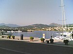
The port of Palinuro
-
View of Palinuro from the sea
-
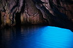
Blue cave
Transport
The town is linked to Salerno and Naples by hydrofoils. The nearest main road is 10 km to the north, connecting Salerno-Battipaglia-Paestum-Agropoli-Vallo della Lucania-Policastro-Sapri.
The nearest railway station, Pisciotta-Palinuro (on the Naples-Reggio Calabria line) is 8 km to the north and is linked to the town by regular buses.
Culture
The Arco Naturale beach of Palinuro was selected as a location in various films including Jason and the Argonauts (1963), Hercules and the Captive Women, and Clash of the Titans.
Climate
| Climate data for Capo Palinuro (1991–2020) | |||||||||||||
|---|---|---|---|---|---|---|---|---|---|---|---|---|---|
| Month | Jan | Feb | Mar | Apr | May | Jun | Jul | Aug | Sep | Oct | Nov | Dec | Year |
| Mean daily maximum °C (°F) | 12.3 (54.1) |
12.5 (54.5) |
14.9 (58.8) |
18.0 (64.4) |
22.5 (72.5) |
27.0 (80.6) |
30.1 (86.2) |
30.8 (87.4) |
27.0 (80.6) |
22.6 (72.7) |
17.8 (64.0) |
13.8 (56.8) |
20.8 (69.4) |
| Daily mean °C (°F) | 10.0 (50.0) |
9.9 (49.8) |
12.0 (53.6) |
14.7 (58.5) |
18.8 (65.8) |
22.9 (73.2) |
25.8 (78.4) |
26.5 (79.7) |
23.0 (73.4) |
19.4 (66.9) |
15.1 (59.2) |
11.5 (52.7) |
17.5 (63.4) |
| Mean daily minimum °C (°F) | 7.8 (46.0) |
7.4 (45.3) |
9.1 (48.4) |
11.5 (52.7) |
15.1 (59.2) |
18.8 (65.8) |
21.6 (70.9) |
22.3 (72.1) |
19.0 (66.2) |
16.2 (61.2) |
12.3 (54.1) |
9.2 (48.6) |
14.2 (57.5) |
| Average precipitation mm (inches) | 89 (3.5) |
70 (2.8) |
67 (2.6) |
63 (2.5) |
37 (1.5) |
19 (0.7) |
14 (0.6) |
21 (0.8) |
65 (2.6) |
87 (3.4) |
121 (4.8) |
96 (3.8) |
749 (29.6) |
| Average precipitation days (≥ 1.0 mm) | 9 | 9 | 8 | 8 | 5 | 2 | 2 | 3 | 5 | 8 | 10 | 10 | 79 |
| Source 1: Istituto Superiore per la Protezione e la Ricerca Ambientale (precipitation 1981–2010) | |||||||||||||
| Source 2: Climi e viaggi (precipitation days) | |||||||||||||
See also
References
- ^ (in Italian) Municipal statute of Centola www.comune.centola.sa.it
- ^ "Buon Dormire Capo Palinuro, Beach located in Centola". www.blueflag.org. Archived from the original on 2007-07-05. Retrieved 2007-08-08.
- ^ Caves of Palinuro www.palinuroculturaevacanze.it
- ^ "Valori climatici normali in Italia". Istituto Superiore per la Protezione e la Ricerca Ambientale. Archived from the original on 17 September 2023. Retrieved 26 November 2024.
- ^ "Valori climatici normali di temperatura e precipitazione in Italia" (PDF). Istituto Superiore per la Protezione e la Ricerca Ambientale. Retrieved 26 November 2024.
- ^ "Clima - Palinuro (Campania)". Climi e viaggi. Retrieved 26 November 2024.
External links
- (in Italian) Palinuro (website)
- (in Italian) Municipality of Centola


